Breaking the ice: Russian oil finds a shorter Arctic route to Asian markets
A new oil terminal at Sever Bay, on the Taymyr Peninsula, gives Moscow a more direct link to Asian buyers while reducing exposure to sea passages controlled by other countries. Copernicus satellite data and ship tracking show the project is already up and running
by Piero Boccardo
On September 5, 2026, Rosneft announced the operational launch of Vostok Oil, its Arctic petroleum project comprising 52 licenses and 13 fields on the Taymyr Peninsula, with estimated reserves exceeding 7 billion tonnes of high-quality crude. The project includes a 790-kilometer pipeline with a 6-kilometer underwater section beneath the Yenisei River, protected by a breakwater that enables year-round navigation. Declared production is 30 million tonnes by the end of 2026, rising to 100 million tonnes at full capacity. Copernicus satellite imagery and ship-tracking data show the announcement is not propaganda: the Sever Bay terminal is already operating, and the first tankers have already loaded and set off with cargo bound for Asian markets.
The three phases of Sever Bay
Three Sentinel-2 acquisitions of the same point in the bay tell, in sequence, the story of the plant’s construction. In the early phase the site is still a small settlement with a dirt airstrip: on the side where the terminal will later rise there is no industrial facility yet, and the bay is free of vessels. In the construction phase the picture changes radically: on the right side of the bay a large construction yard takes shape, and a tidy line of roughly ten vessels sits moored in the bay, consistent with the traffic needed to build an industrial plant in a place with no road access. In the operational phase the construction yard has become a recognizable facility, with aligned storage tanks and a complete internal road network; the bay, which in the previous phase was crowded with traffic, is now nearly empty, with a single vessel moored at the dock, the typical sign of a terminal that has stopped receiving construction materials and started loading crude.
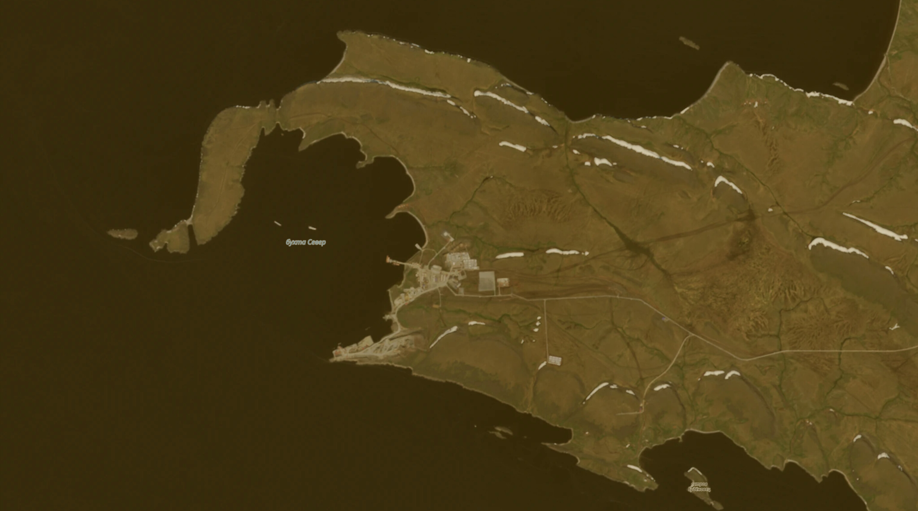
Sever Bay, early phase. The original small settlement and a dirt airstrip; on the side where the terminal will later rise there is no industrial facility yet, and the bay is free of vessels. Credit: Sentinel-2, Copernicus.
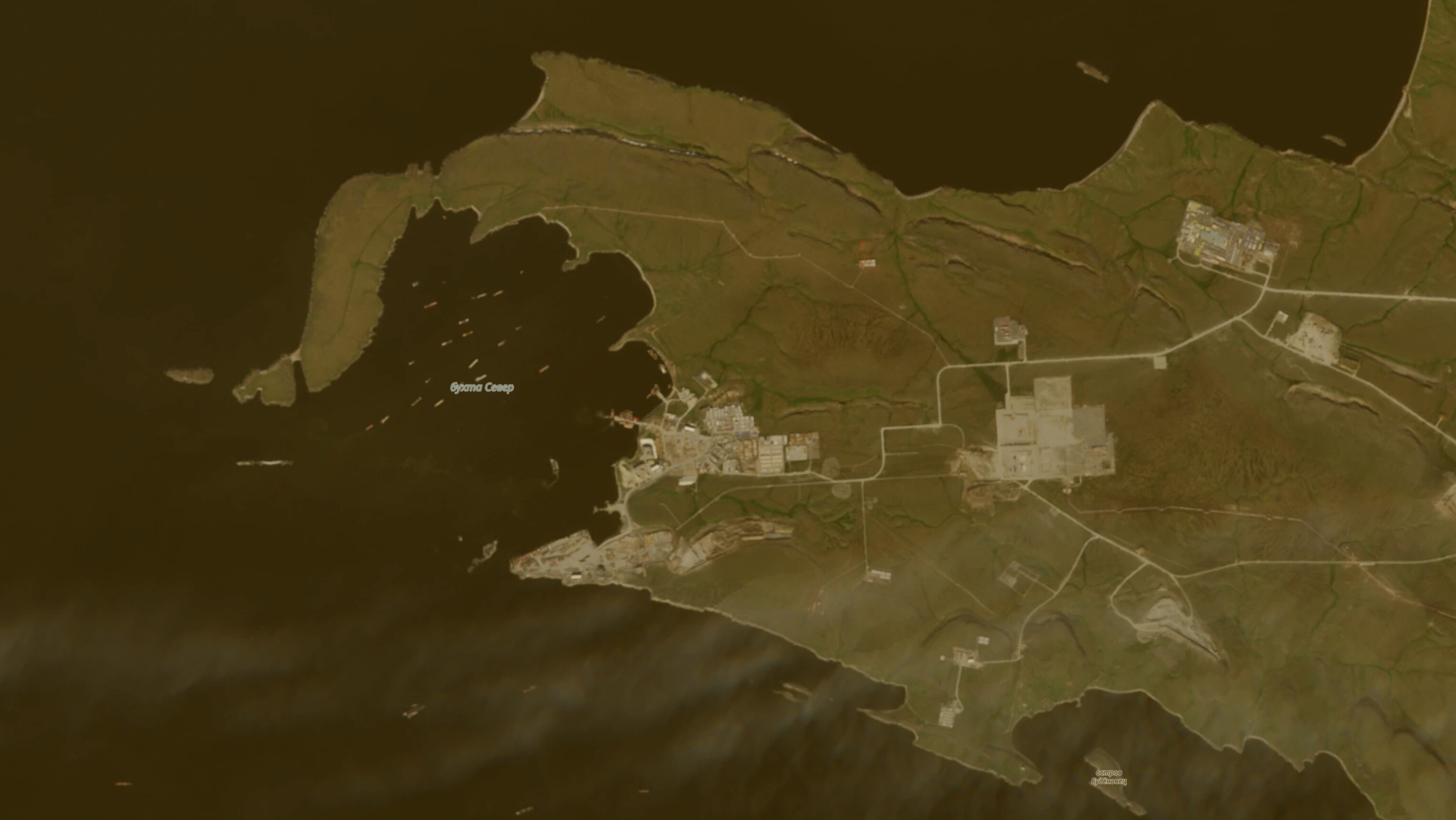
Sever Bay, construction under way. On the right side of the bay a large construction yard takes shape, and a tidy line of roughly ten vessels sits moored in the bay, consistent with the traffic needed to build an industrial plant in a place with no road access. Credit: Sentinel-2, Copernicus.
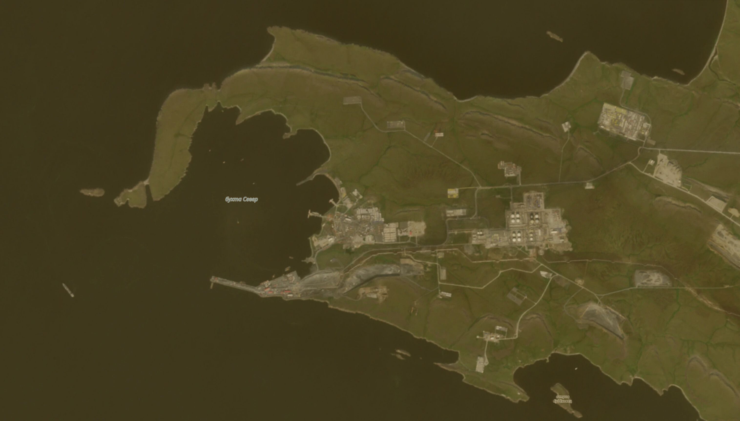
Sever Bay, operational terminal. The construction yard has become a recognizable facility, with aligned storage tanks and a complete internal road network; the bay, which in the previous phase was crowded with traffic, is now nearly empty, with a single vessel moored at the dock. Credit: Sentinel-2, Copernicus.
Tankers on the route
AIS tracking via MarineTraffic confirms the terminal is already moving cargo. The Valentin Pikul, a Russian-flagged Aframax tanker (69,323 deadweight tonnes, roughly 506,000 barrels), arrived at Sever Bay on September 3, 2026 after departing on August 30, with a draft of 10.3 meters: it loaded the first documented Vostok Oil cargo. The Akademik Gubkin, a Suezmax tanker (112,909 deadweight tonnes, roughly 824,000 barrels), was recorded on August 21 off the Bering Strait, on a declared route to Sever Bay after departing on August 11, with an estimated arrival around September 5: a voyage of roughly 5,600 kilometers along the Northern Sea Route at a cruising speed of 10.3 knots. In both cases the reported position is the last AIS transmission received, not a real-time position.
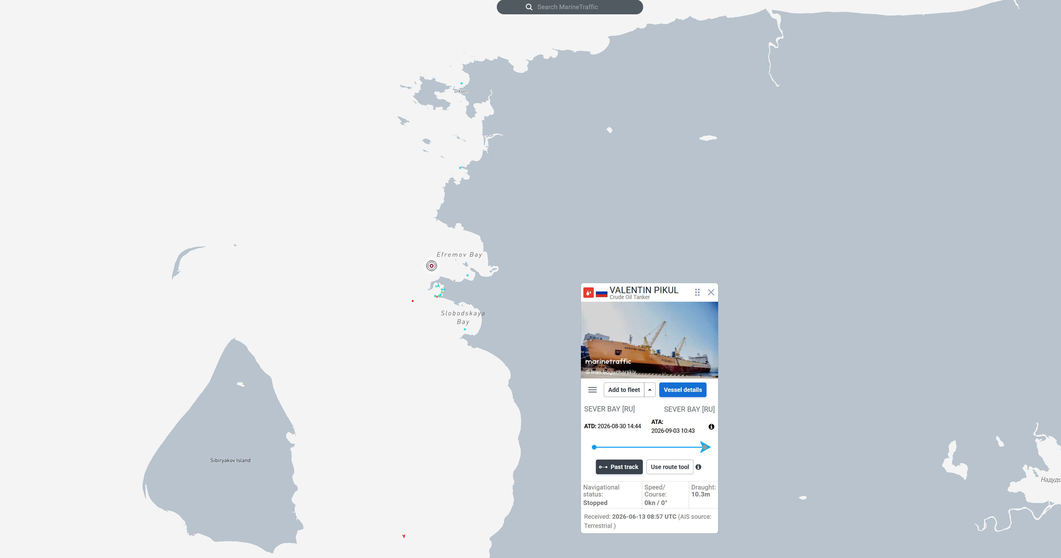
MarineTraffic record for the Valentin Pikul, a Russian-flagged crude tanker. The position reflects the last AIS transmission received at the time of the screenshot, not necessarily a real-time position. Credit: MarineTraffic.
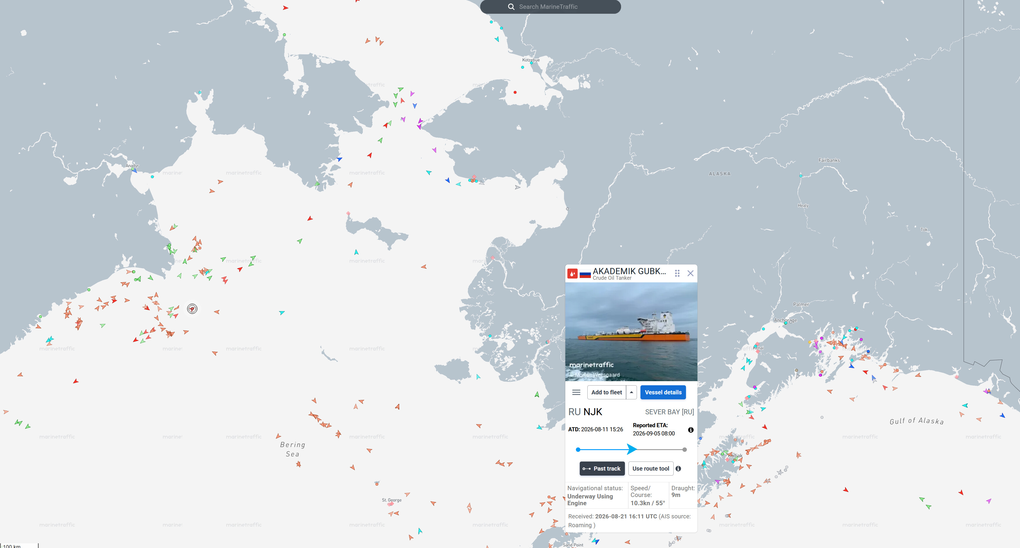
MarineTraffic record for the Akademik Gubkin, a Russian-flagged crude tanker, positioned off the Bering Strait. The data point is from August 21, 2026, via satellite AIS: not a real-time position, but the last known point along the ship’s route. Credit: MarineTraffic.
A shorter Arctic route
The new terminal’s geographic advantage is measured by the gap between two routes. From Sever Bay, the Northern Sea Route reaches Ningbo, China, in roughly 10,800 kilometers. From Equinor’s Norwegian terminal at Sture, the same arrival via the Suez Canal requires roughly 19,600 kilometers, 45% more. At a tanker’s typical cruising speed of about 14 knots, that gap translates into 17 days of sailing versus 31, a saving of roughly two weeks per voyage.
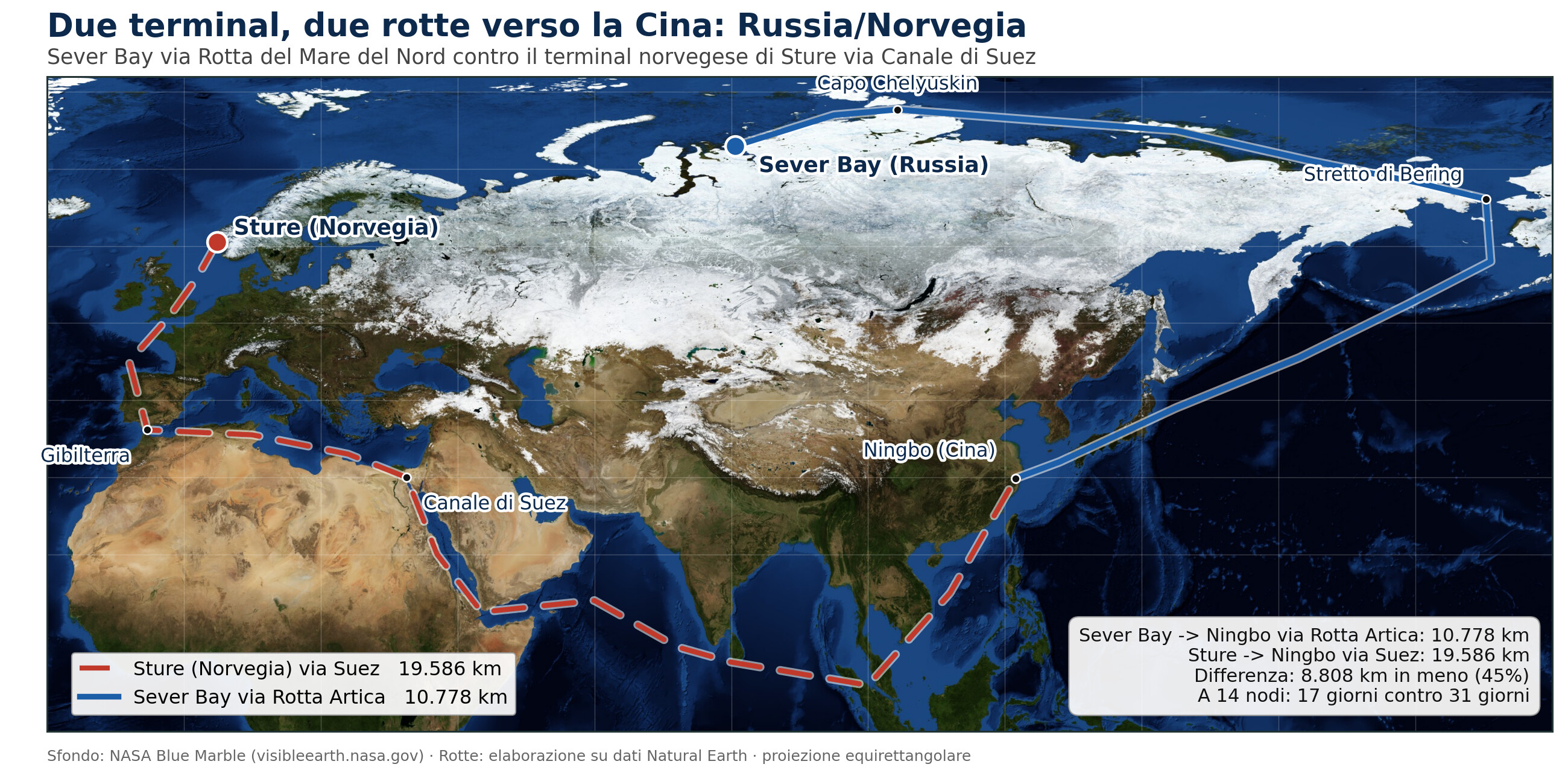
Sever Bay via the Northern Sea Route (in blue) versus Norway’s Sture terminal via the Suez Canal (dashed red), both arriving at Ningbo, China. Distances calculated as the sum of geodetic legs along realistic navigation waypoints, not straight-line distance. Credit: author’s elaboration on Natural Earth data, Mercator projection.
What the saving is worth
In cost terms, the saving for the Valentin Pikul comes to roughly $270,000 in fuel over the 14-day difference, plus roughly $400,000 in avoided Suez Canal fees: about $670,000 per voyage, or $1.30 a barrel. For the Akademik Gubkin, larger and therefore burning more fuel per day, the estimated total saving is roughly $766,000 per voyage, or $0.93 a barrel. At an annual output of 30 million tonnes, roughly 219 million barrels, even a conservative saving of $1 a barrel comes to about $219 million a year.
Why the Russian route matters
Vostok Oil is not just an oil field: it is a piece of Russia’s strategy to build direct access to Asian markets, China, India, Indonesia, independent of the chokepoints the West monitors most closely. Until now, exporting sanctioned Russian crude has relied mainly on the shadow fleet and ship-to-ship transfers in international waters, tactics that are hard to trace but also hard to scale. An entirely Russian-controlled logistics infrastructure, bypassing Suez and the Cape of Good Hope, is a different kind of step: it shifts great-power competition into Arctic waters, where it nonetheless remains physically traceable through satellite monitoring.
A note on methodology
The AIS positions reported by MarineTraffic are the last transmission received at the time of the check, not a real-time position: the vessel may have already moved on from the point shown. Distances between terminals are calculated as the sum of geodetic legs along realistic shipping-route waypoints, not as straight-line distance. The savings estimates combine a verified fuel price (VLSFO, roughly $680 a tonne, Rotterdam, source Ship & Bunker) with daily consumption figures estimated from industry standards (28 tonnes a day for an Aframax, 38 for a Suezmax) and an estimated Suez toll of around $400,000 per transit: these are scenario figures, not case-by-case verified data. The calculation also excludes icebreaker escort costs along the Northern Sea Route and ship charter costs, so it should be read as an estimate of the maximum possible advantage, not a guaranteed net margin.
Sources: Sentinel-2 satellite imagery, Copernicus; MarineTraffic ship-tracking data (AIS); The Maritime Executive; Luxembourg Times; OilPrice.com; Natural Earth vector data; Ship & Bunker fuel pricing; Sture terminal data for comparison, Equinor. Map and statistical processing by Piero Boccardo, Politecnico di Torino. Published on Linkiesta, September 15, 2026.