The growing archipelago
The artificial islands China has built in the South China Sea are only visible from satellites. Except that Europe's public satellite, contrary to common assumption, barely looks there
by Piero Boccardo
The runway is three kilometres long, paved, lit, and equipped with a control tower, reinforced hangars and missile shelters. It is usable by H-6 bombers, J-11 fighters and long-range maritime patrol aircraft. Ten years ago, in its place, there was a semi-submerged coral reef, a few tens of metres wide, inhabited by fish and turtles. The transformation of that atoll into a permanent military base took place between 2014 and 2017, and it is one of seven similar projects China has carried out in the Spratly Islands. The detailed chronicle of that transformation exists only because satellites photographed it, week after week.
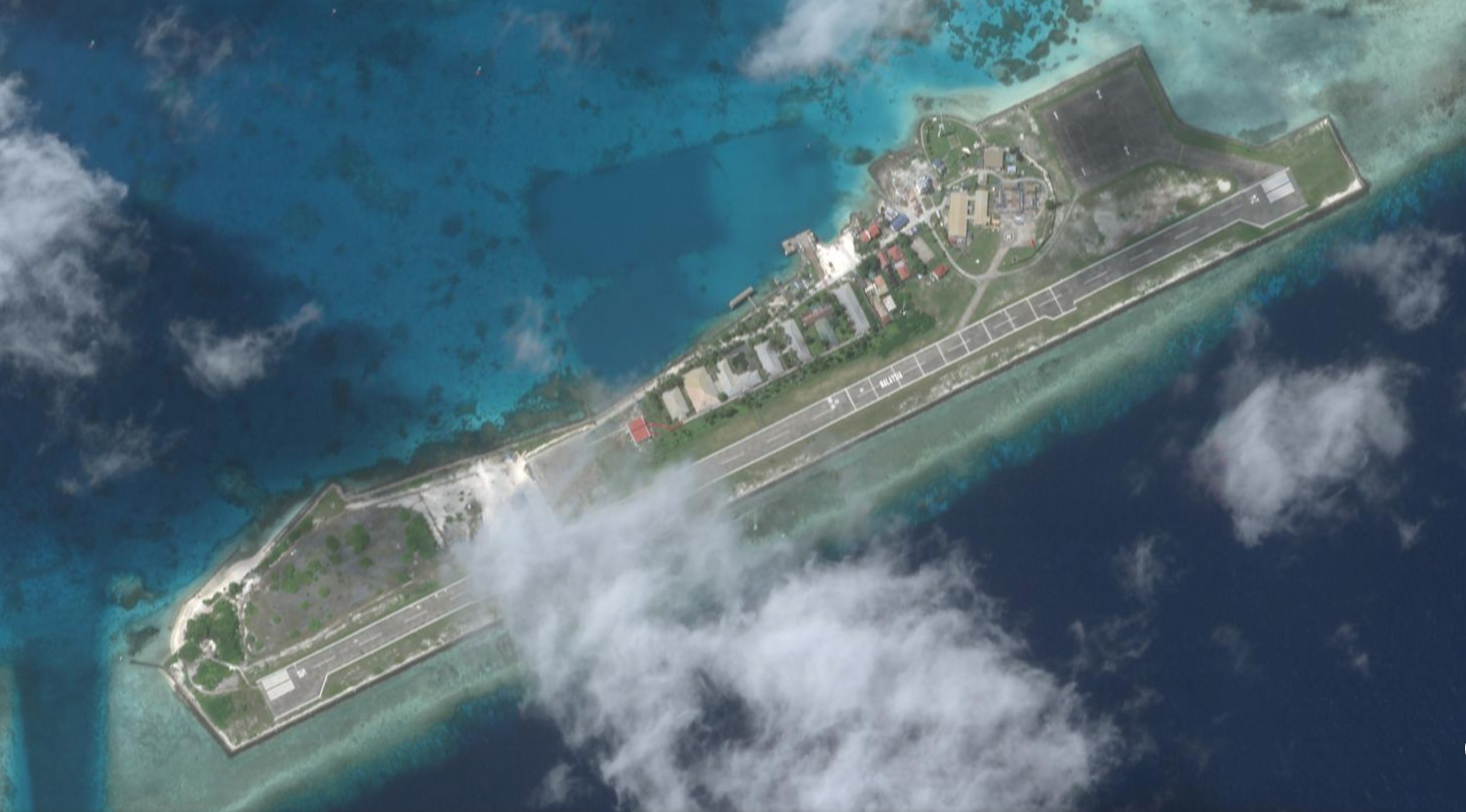
One of the artificial islands in the Spratlys, seen from Planet SkySat. Visible are the roughly three-kilometre runway, the covered hangars, the military port to the west, and the complex of administrative and residential buildings. The squared shoreline is the mark of its origin: the reef was dredged and filled with seabed sand to create a usable surface. None of the infrastructure visible here existed before 2014. — Planet Labs
The South China Sea is one of the most contested stretches of water on the planet. China, Taiwan, Vietnam, the Philippines, Malaysia, Brunei and Indonesia all border it, and each of these countries claims varying portions of its waters, seabeds and islets. China, in particular, asserts a line — the so-called nine-dash line — that encloses roughly 90 per cent of the basin and which, according to Beijing, has been part of national territory “since time immemorial”. In 2016, the Permanent Court of Arbitration in The Hague, at the request of the Philippines, ruled that this line had no legal basis under the United Nations Convention on the Law of the Sea, and that China, by building its artificial islands, had violated the rights of its neighbours and permanently damaged the marine environment. Beijing rejected the ruling on the same day, and its strategy has not changed since: continue transforming reefs and coral atolls into garrisoned bases, knowing that each new square metre of land pushes the line of fait accompli further forward.
From the ground, practically nothing is visible. The Spratly Islands lie hundreds of kilometres from any coast, Chinese warships patrol the area, and access for independent journalists and researchers is effectively impossible. Everything we know about the progress of construction comes from a handful of sensors in orbit.
The natural instinct is to search on Copernicus Browser, the public interface of the Sentinel satellites. But attempting this reveals something often taken for granted that is not true: over the Paracels, and across much of the South China Sea, the archive is nearly empty. Sentinel-2, the optical satellite, systematically acquires over land and coastal strips but not over open seas, and oceanic atolls fall outside the acquisition tiles. Sentinel-1, the radar, covers the area in Extra Wide swath mode, at roughly 40 metres resolution and monthly cadence: useful for identifying large vessels, not for documenting the dredging of an atoll. Copernicus, in other words, has a geographic hierarchy built around Europe, land and coastlines, and leaves uncovered precisely the parts of the world most relevant to geopolitical reporting.
Documenting what happens between the Spratlys and the Paracels falls, to a large extent, to commercial operators. The backbone is American: SkySat, from California-based Planet, is a constellation of twenty-one small optical satellites in sun-synchronous orbit at around 500 kilometres altitude, delivering images at roughly 50 centimetres resolution and taskable on specific targets on demand; Pelican, also from Planet, is the new generation progressively replacing SkySat, with 30-centimetre resolution, near-real-time inter-satellite connectivity and a planned final constellation of around thirty units. Maxar and BlackSky, also American, round out the main providers.
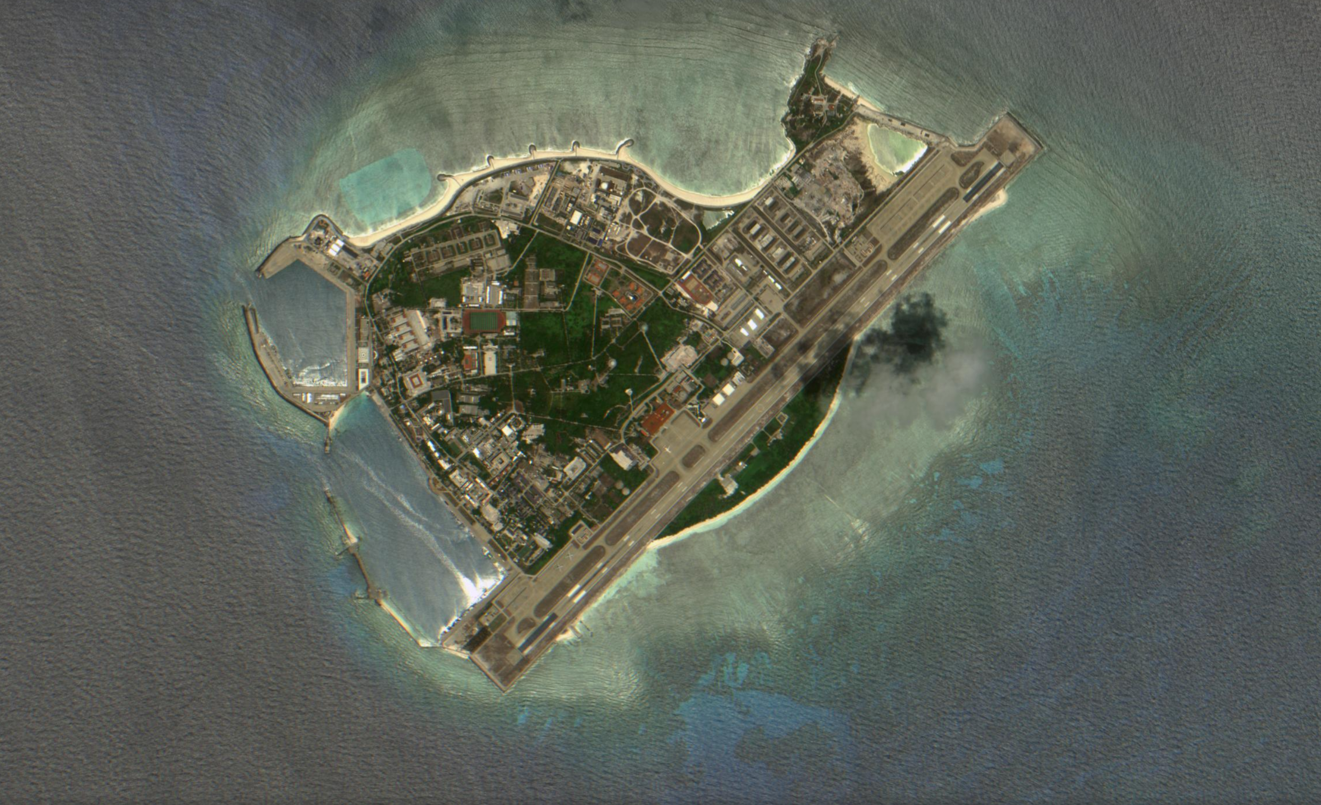
A Paracel Islands atoll, occupied by China since 1974, photographed by Planet Pelican. Two runways are visible: the one at the top, on the main island, has been in service for years; the one at the bottom, on a sandy cay that until a few seasons ago was at water level, is of recent construction. Together, the two runways double China’s operational capacity over the archipelago. — Planet Labs
It would however be wrong to read this picture as one of complete dependence on the American market. Over the South China Sea, European operators also work with regular frequency: Airbus with the Pléiades Neo family, offering resolutions down to thirty centimetres, and Finnish company ICEYE with a commercial SAR constellation that sees at night and through clouds at metre-scale resolution. These are sources that some think tanks — including the Asia Maritime Transparency Initiative at the Center for Strategic and International Studies — systematically integrate into their analyses, alongside Maxar and Planet imagery.
There is also a third level of observation, concerning not land but the movement of vessels. Beijing does not limit itself to building islands: it uses a large fleet of civilian fishing vessels — the so-called maritime militia — to effectively garrison reefs that are still officially contested, and to obstruct Filipino and Vietnamese fishermen. When they want to hide, they switch off the AIS transponder that should broadcast their position. Here too, instead of Sentinel-1, in this part of the world the tracks are reconstructed by cross-referencing commercial AIS data (Spire, Kpler, MarineTraffic) with commercial SAR imagery, primarily Capella and ICEYE.
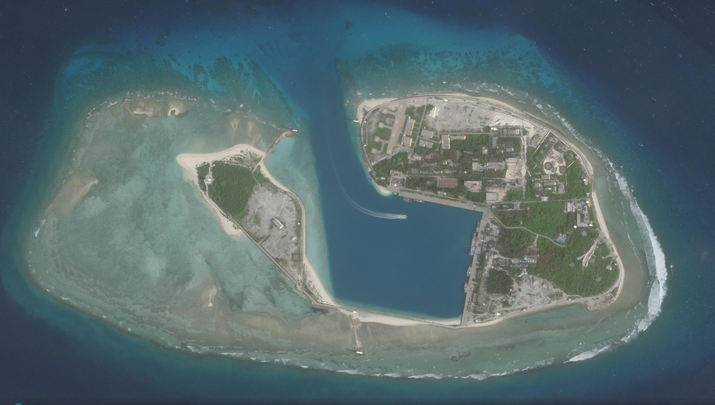
Another Paracel atoll, photographed by Planet SkySat. The right portion of the island houses a small Chinese administrative centre; the left portion, still being consolidated, shows a newly built quay and a sandy storage area. Between the two lobes of the atoll, a protected internal harbour has been carved out, recognisable from the wake of a small vessel in transit. — Planet Labs
Europe is working on the next generation of Sentinels — Sentinel-1NG is due to enter service by the end of the decade — and some member states are strengthening their national capabilities, from France’s CSO to Germany’s SARah. These are largely institutional assets, not open like Copernicus, but they are pieces of the same evolving mosaic.
The moral of the artificial archipelago is twofold. First: the chronicle of one of the most fundamental geopolitical transformations of the past decade exists because a market of commercial operators — predominantly but not exclusively American — decided to sell imagery to journalists, researchers and think tanks. Without that market, the archipelago would already be a historical footnote. Second: the geography of what European audiences can see reflects the priorities with which Copernicus was built twenty years ago, and it is a geography that risks leaving uncovered precisely the scenarios most relevant to European security and public opinion. Deciding where to look, in the end, is already deciding.