Fires in Africa, 2026: 134 times Europe
Data from the Global Wildfire Information System describe a fire season out of scale compared to Europe's, and at the same time well below the continent's own historical average
by Piero Boccardo
While Europe closes out a summer of fires that has already passed the halfway mark of the record-setting 2025 season, on the other side of the Mediterranean a continent is burning on a scale that makes those numbers look almost trivial. Data from GWIS (Global Wildfire Information System), the Copernicus Emergency Management Service that has monitored fires worldwide since the early 2000s by combining MODIS and VIIRS satellite detections, show that between January 1 and August 31, 2026, more than 85 million hectares burned across 52 African countries and territories — more than 130 times the area burned in the same period across the European Union. Yet, as the comparison with the 2012-2025 average for the same period shows, this African season is not an anomaly. It is, in fact, substantially below the norm.
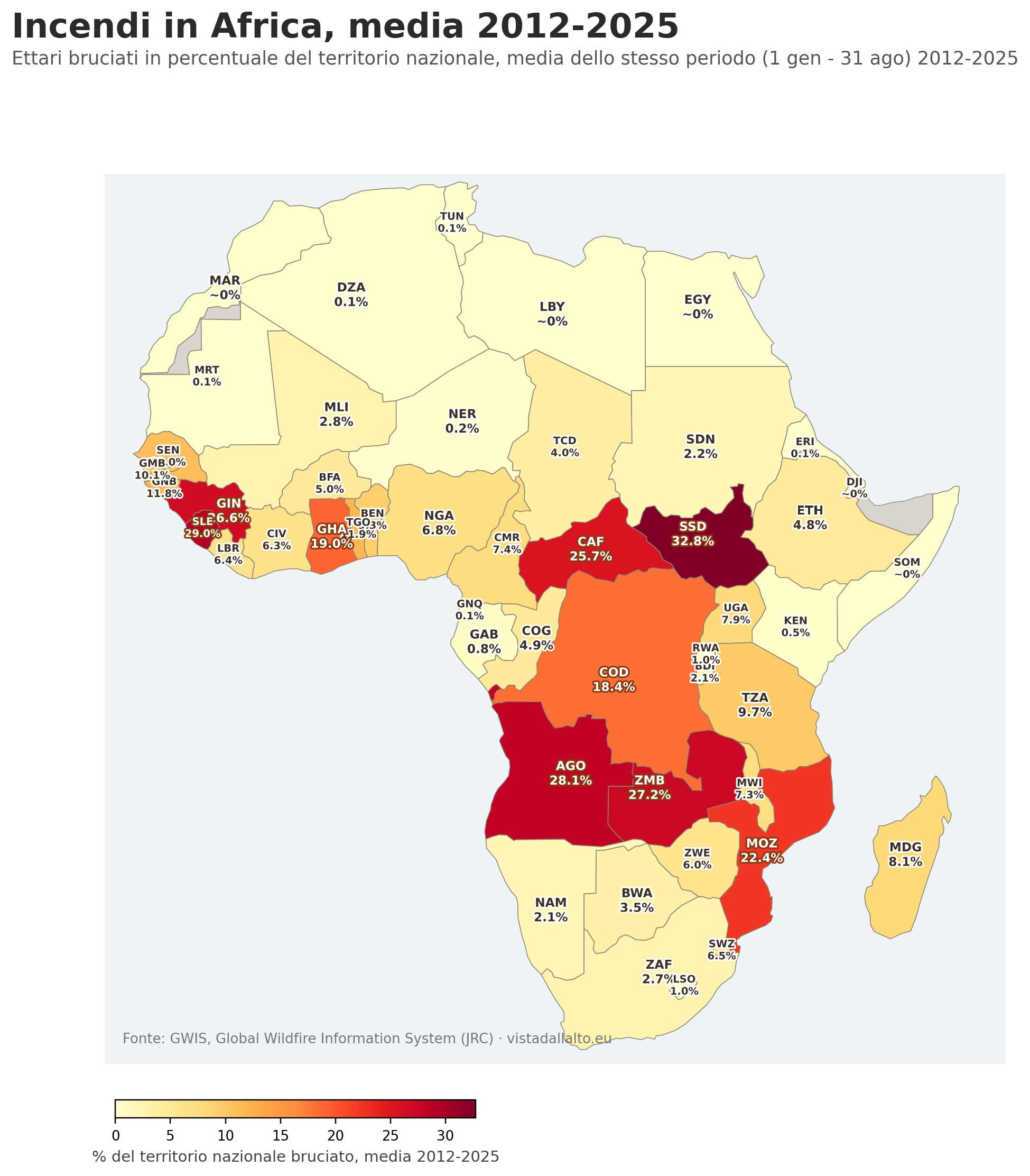
Figure 1a — Fires in Africa, 2012-2025 average for the same period (January 1 - August 31). Source: GWIS, Global Wildfire Information System (JRC).
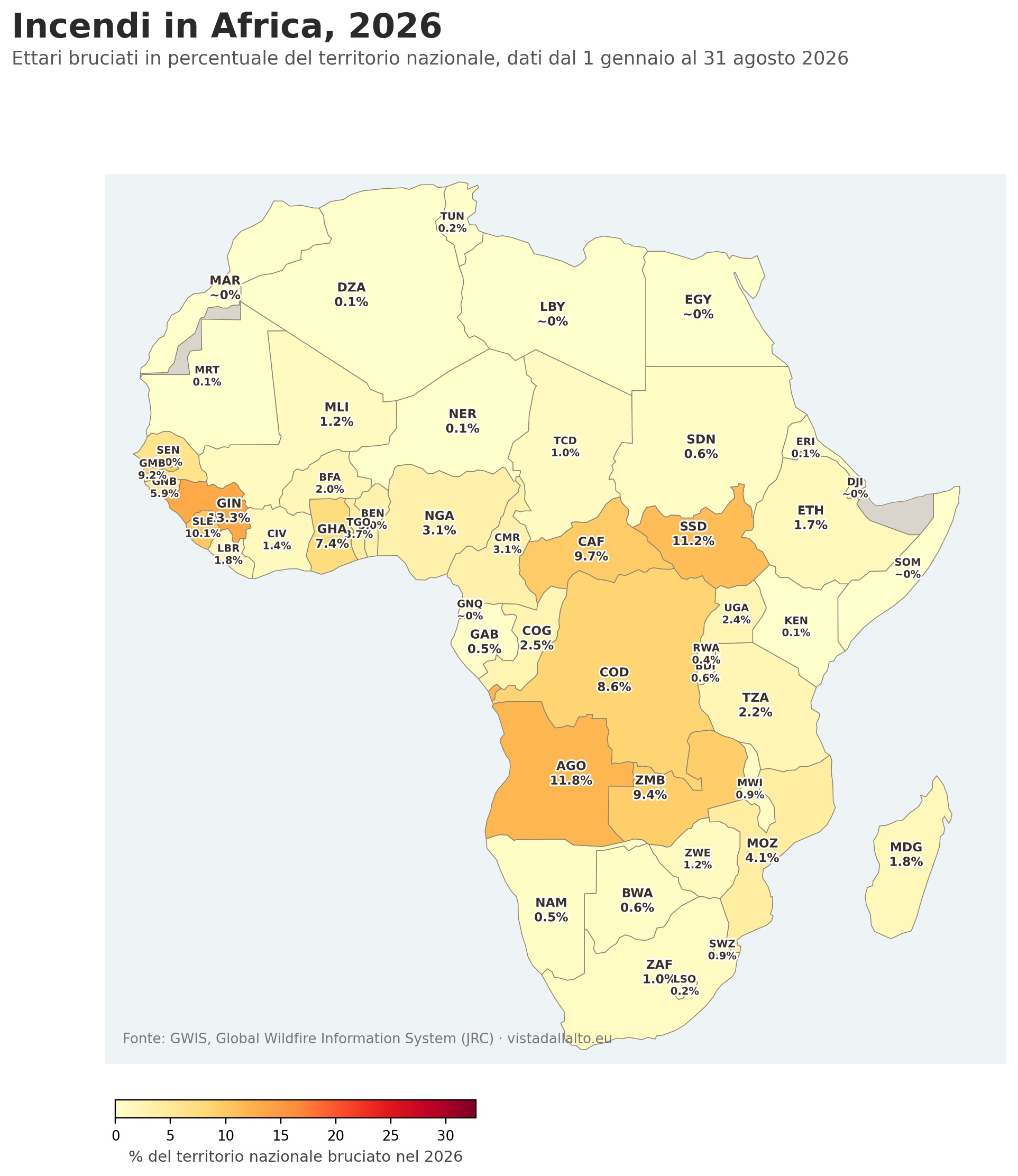
Figure 1b — Fires in Africa, the 2026 season updated to August 31. Same color scale as the previous map, for a direct comparison. Source: GWIS, Global Wildfire Information System (JRC).
A scale with no equivalent in Europe
The first striking figure is purely one of magnitude. Across the 52 African countries and territories tracked by GWIS, the area burned between January 1 and August 31, 2026 exceeds 85 million hectares. In the same period, the 23 EU countries for which GWIS records significant data totaled about 635,000 hectares: the Democratic Republic of Congo alone, with more than 20 million hectares burned, accounts for more than 31 times the entire European Union. Angola, with nearly 14.7 million hectares, exceeds it by a factor of 23. Even a single mid-sized country like Zambia or South Sudan burns, on its own, more hectares than the whole European continent tracked by EFFIS.
This is not a new phenomenon. Scientific literature attributes to Africa between 60% and 70% of all area burned globally each year, most of it in tropical savannas and grasslands where fire has long been part of traditional land management, used for grazing and for renewing agricultural land.
This is also why some countries reach such extreme percentages — more than 30% of the entire national territory burned in a single year for South Sudan, Angola and Zambia. Across the vast grassy plains and seasonal wetlands that cover much of these countries, such as the Sudd region in South Sudan, pastoral communities systematically burn dry vegetation every year at the end of the dry season, to encourage the regrowth of tender grass for livestock, to make hunting easier, and to prepare land for the following agricultural season. It is a cycle that repeats on the same land year after year, which is why these figures do not describe a sequence of disasters but a fire regime that is largely voluntary and recurring, of a very different nature from the forest fires that hit Mediterranean Europe. Independent confirmation comes from scientific literature: a study of a West African savanna reserve measured that 71.9% of its area burns on average every year (Zoffoun et al., 2023), an order of magnitude consistent with what is observed in South Sudan.
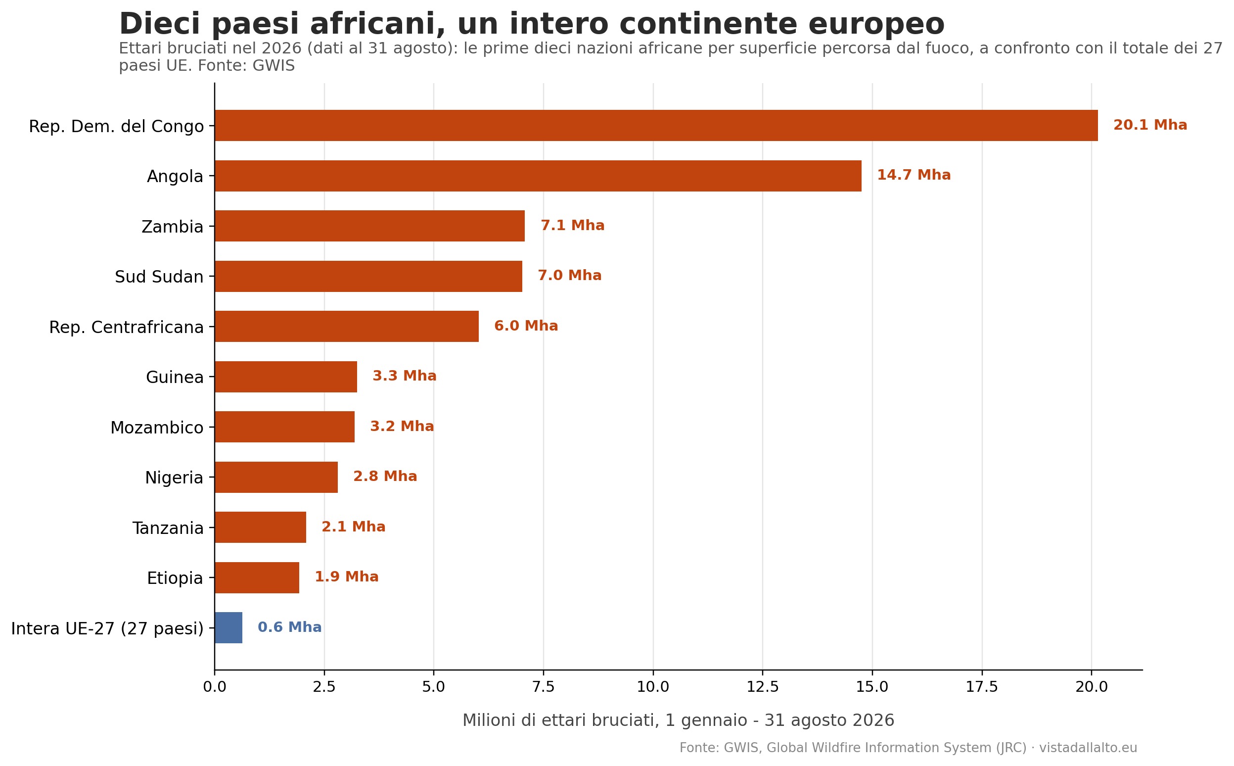
Figure 2 — Hectares burned in 2026 (data to August 31) in the ten African countries with the largest area affected by fire, compared with the total for EU countries tracked by GWIS in the same period. Source: GWIS.
A below-average season, not a disaster
The most interesting figure, however, comes from the historical comparison. The 2012-2025 average for the same period of the year, across the same 52 countries, is about 231 million hectares: the 2026 season, with its 85 million hectares, sits at roughly 37% of that average. In other words, the continent that on its own burns more than a hundred times the area of Europe is, this year, going through a fire season markedly more contained than its own historical standard.
This is not an isolated case in 2026. It confirms a long-term trend documented by several scientific studies. Global burned area has declined by about 24% over the past two decades, with the sharpest drop precisely in African savannas, and agricultural expansion is cited as one of the main drivers of this change, together with landscape fragmentation, which makes it harder for fires to spread over large areas (Andela et al., 2017). An analysis of Central Africa alone estimated a decline in burned area of 2.7-3.2 million hectares per year between 2003 and 2017, roughly 1.3% per year, driven mainly by a reduction in the number and size of large fires (Jiang et al., 2020). Another continent-wide survey, covering 2002-2016, measured an 18.5% decline in burned area, with 80% of the reduction concentrated in the northern hemisphere (Zubkova et al., 2019).
The causes of this decline remain partly debated. Studies agree that agricultural expansion and intensification play a role, but not all of them find it to be the main explanation, and the same 2002-2016 study notes that variations in rainfall and soil moisture explain a substantial share of the phenomenon, in some cases more than the share attributable to land-use change (Zubkova et al., 2019). What does appear solid, in the more recent literature, is that the African continent remains by far the largest contributor to global burned area, even as that area declines year after year (Andela et al., 2017; Jiang et al., 2020).
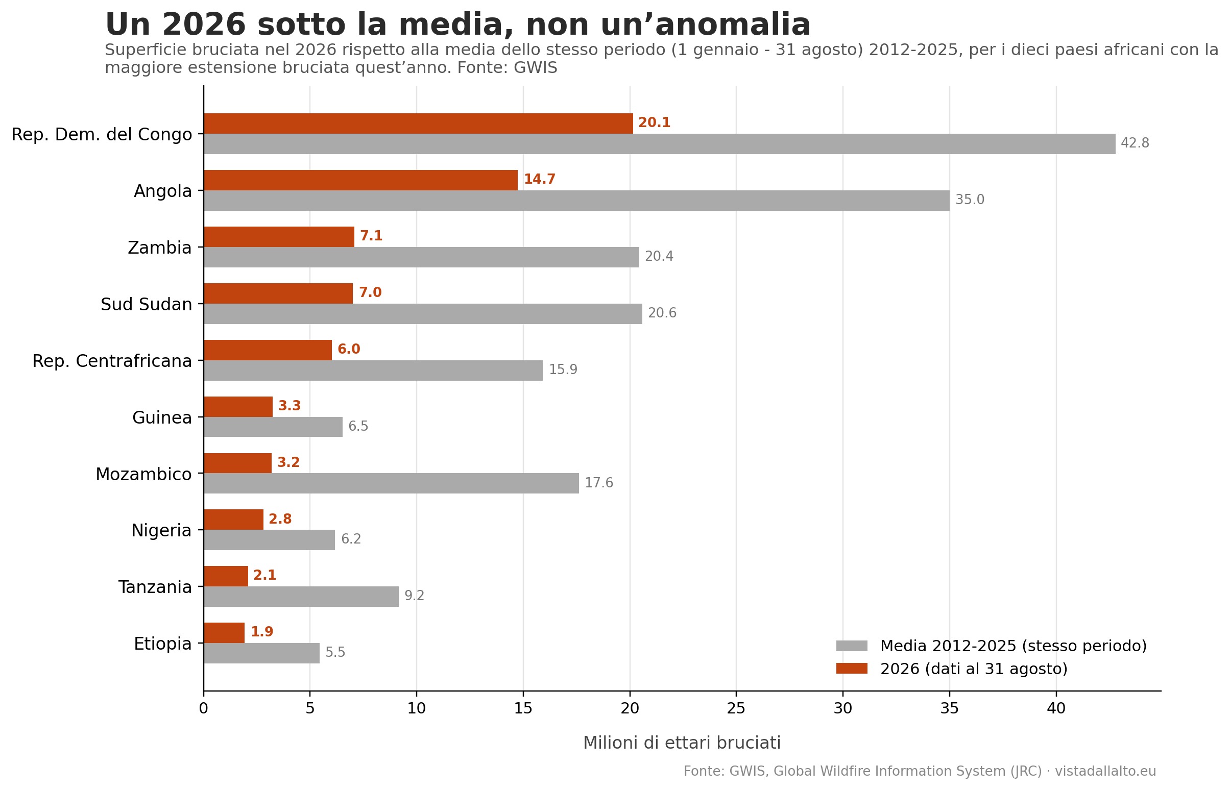
Figure 3 — Burned area in 2026 (data to August 31) compared with the average for the same period in 2012-2025, for the ten African countries with the largest burned area this year. In all ten cases, 2026 is markedly below average. Source: GWIS.
Methodological note
The data in this piece come from the GWIS Statistics Portal (Estimates section), which estimates burned area using a spatio-temporal clustering algorithm applied to thermal anomalies detected by the MODIS and VIIRS sensors. This differs from the approach used by EFFIS for Europe, which relies on near-real-time MODIS detection at 250-meter resolution integrated with Sentinel-2: the two methodologies are not directly comparable hectare for hectare, even though both are part of the broader Copernicus ecosystem.
It should also be noted that GWIS data can include intentional land-management fires (controlled burning for grazing or agricultural renewal), particularly widespread in African savannas, and does not systematically distinguish these events from unplanned fires — a factor worth keeping in mind when interpreting the large absolute figures cited in this piece. Data were collected from the GWIS portal on August 31, 2026 and cover the period from January 1 to August 31 of each year considered.
Sources: GWIS, Global Wildfire Information System, Copernicus Emergency Management Service, JRC (data updated to August 31, 2026); Andela N. et al., “A human-driven decline in global burned area”, Science, 2017; Jiang Y. et al., “Observed changes in fire patterns and possible drivers over Central Africa”, Environmental Research Letters, 2020; Zubkova M. et al., “Changes in Fire Activity in Africa from 2002 to 2016 and Their Potential Drivers”, Geophysical Research Letters, 2019; Roteta E. et al., “Development of a Sentinel-2 burned area algorithm: Generation of a small fire database for sub-Saharan Africa”, Remote Sensing of Environment, 2019; Zoffoun O.G. et al., “Distribution patterns of fire regime in the Pendjari Biosphere Reserve, West Africa”, Journal of Arid Land, 2023; cartographic and statistical elaboration by Piero Boccardo, Politecnico di Torino.