War in the Middle East: what maps and satellite images show
Geographic distribution of the strikes, territorial depth, proximity to strategic corridors: the data point to a structural transformation, not a contingent episode
by Piero Boccardo
For years Iran was described as a destabilizing but peripheral actor, confined to a regional dimension made of proxies, militias and intermittent tensions. The maps of the past few days tell a different story. And data, when examined carefully, has one virtue: it forces us to take seriously what rhetoric tends to simplify.
The first piece of evidence is geographic. In the 48 hours between February 28 and March 1, 2026, US and Israeli strikes did not concentrate on a single symbolic node, but hit deep into the entire Iranian territory. From the Tabriz region in the northwest, where satellite images show collapsed missile tunnels, to the Konarak naval base on the Gulf of Oman, passing through the Tehran area and Mehrabad airport, the distribution of the strikes describes a coordinated, multi-layered campaign.
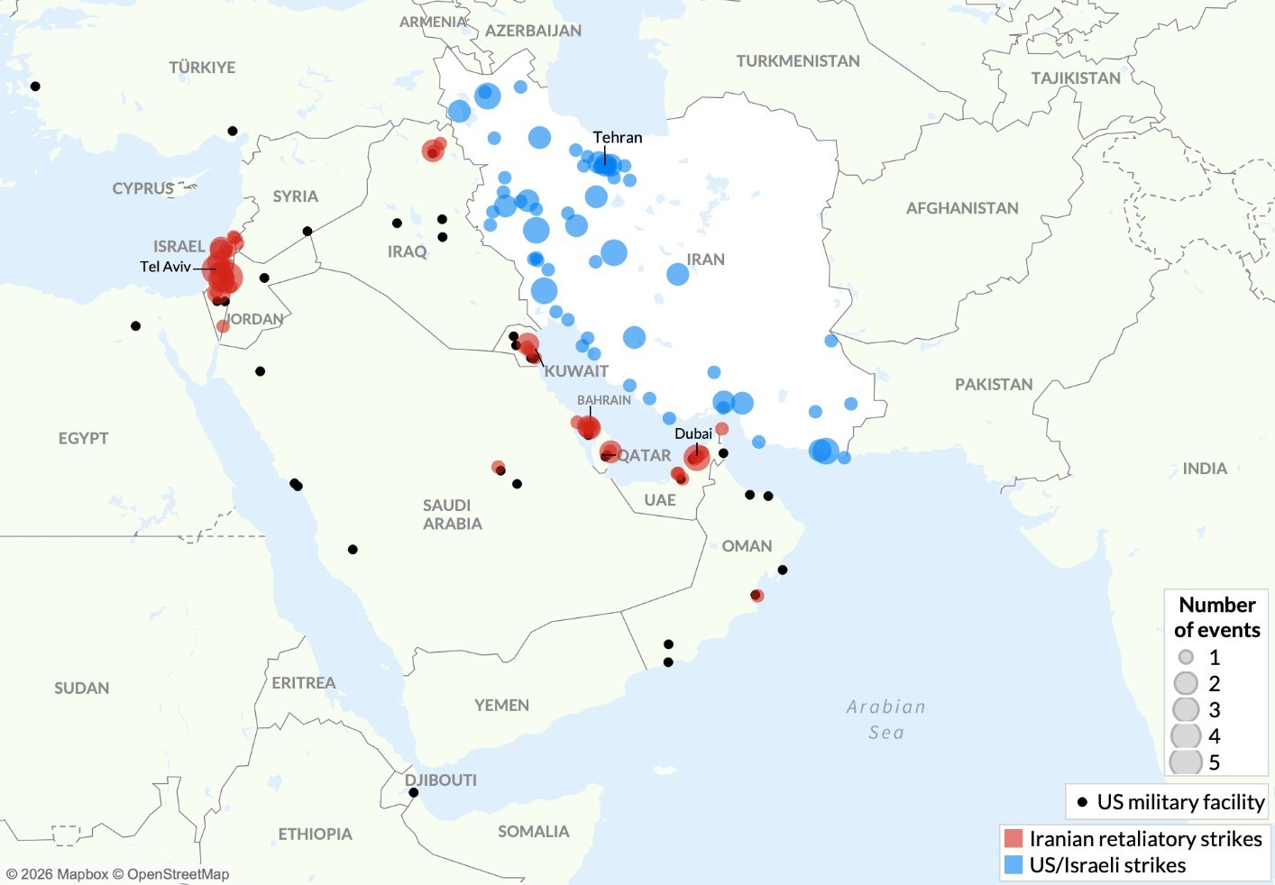
Figure 1 — Strikes by the United States-Israel coalition (in blue) and Iranian retaliatory strikes (in red) in the period February 28, 2026 - March 1, 2026. Black dots mark US military installations in the region. Source: ASP (American Security Project) via ACLED.
This is not a demonstrative raid. It is a strategy.
Comparing the map of the June 2025 strikes with the current one, the jump in scale is evident. In 2025 the strikes were relatively concentrated around a few strategic nodes, mostly in the central and northwestern area of the country. In 2026 the distribution is national: southern coast, eastern depth, internal corridors. Not just more power (vertical escalation), but more territory (horizontal escalation). The war is not just intensifying: it is expanding.
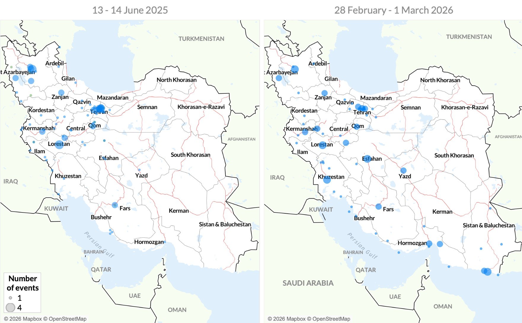
Figure 2 — On the left, the Israeli strikes of June 13-14, 2025, concentrated on a few nodes in the central and northwestern area of Iran. On the right, the strikes by the United States-Israel coalition between February 28 and March 1, 2026: the distribution is now nationwide, with the southern coast and the eastern belt involved for the first time. Source: ASP (American Security Project) via ACLED.
This expansion has an immediate consequence. When a conflict spreads along the entire territorial backbone of Iran, it does not stay confined within its borders. The overall map of events shows a second structural element: Iran’s response is not linear, but networked.
Retaliatory strikes are not limited to Israel, where the Tel Aviv area appears as the main symbolic and operational target. They extend to the Gulf, involving areas near US bases in Kuwait, Qatar, and the United Arab Emirates. The black dots marking American military installations point to a fact that is hard to dispute: the architecture of the US presence in the region is an integral part of the war theater.
Analytically, we are not looking at a bilateral conflict, but at an interconnected system. The network of bases, energy infrastructure, and civilian and military airports forms a single mesh. Hitting one node means stressing the entire system.
Tabriz: the missile galleries
The most sensitive element, from a global point of view, is the southern Iranian belt. The images relating to Hormozgan province and the areas near the Strait of Hormuz introduce a systemic variable. About a fifth of the world’s oil passes through that strait. This is not a rhetorical figure, it is a logistical proportion. Any credible threat to the security of that corridor produces immediate effects on maritime insurance, energy futures, financial volatility.
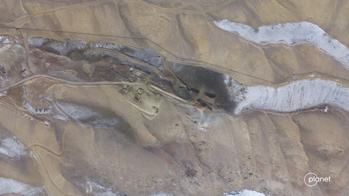
Figure 3 — Missile base north of Tabriz, before the strike: the entrance to the tunnel dug into the mountain is intact. Source: Planet Labs PBC.
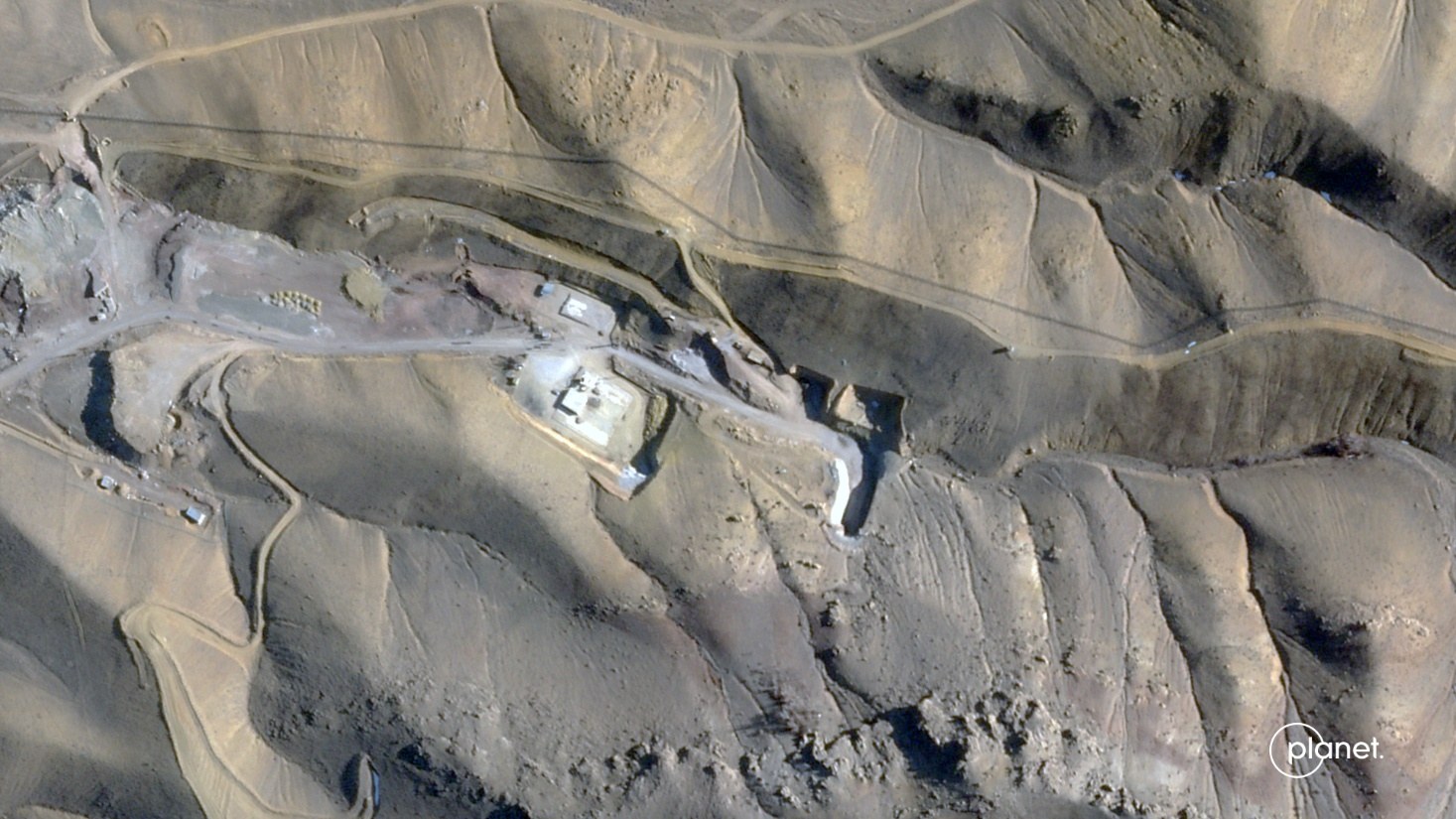
Figure 4 — Same site after the strike: the missile tunnel has collapsed. Source: Planet Labs PBC.
When the maps show military activity in that region, the conflict by definition ceases to be regional.
The satellite imagery adds a further layer of analysis. The collapse of the missile tunnels at Tabriz points to an attempt to degrade long-range deterrence capability. The damage to the Konarak naval base suggests pressure on Iran’s maritime component. The strikes on airport infrastructure, such as Mehrabad, signal the intent to hit not only military assets but dual-use logistics nodes. Even the fire documented in Dubai, in a different context, is a reminder of how quickly a hyperconnected urban system can become vulnerable in an extended conflict environment.
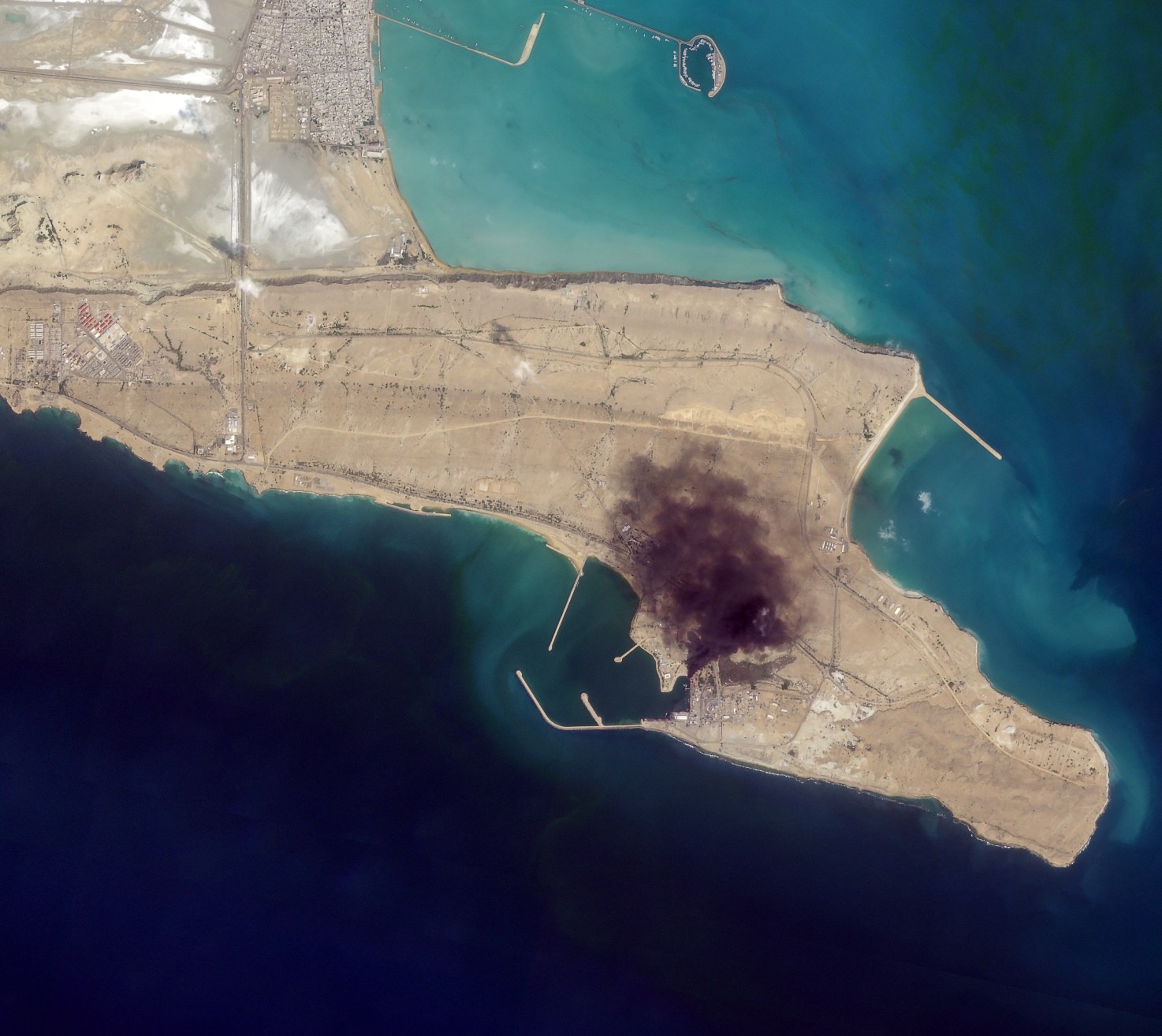
Figure 5 — Bombing of the Konarak naval base on the Gulf of Oman: a plume of black smoke from fires along the pier is visible. Source: Planet Labs PBC.
Contemporary wars are not fought only against armies. They are fought against infrastructure.
This shift is crucial. Infrastructure — ports, airports, bases, energy hubs — is what makes economic life possible. It is the invisible backbone of globalization. Hitting it means generating multiplier effects: logistical, financial, psychological.
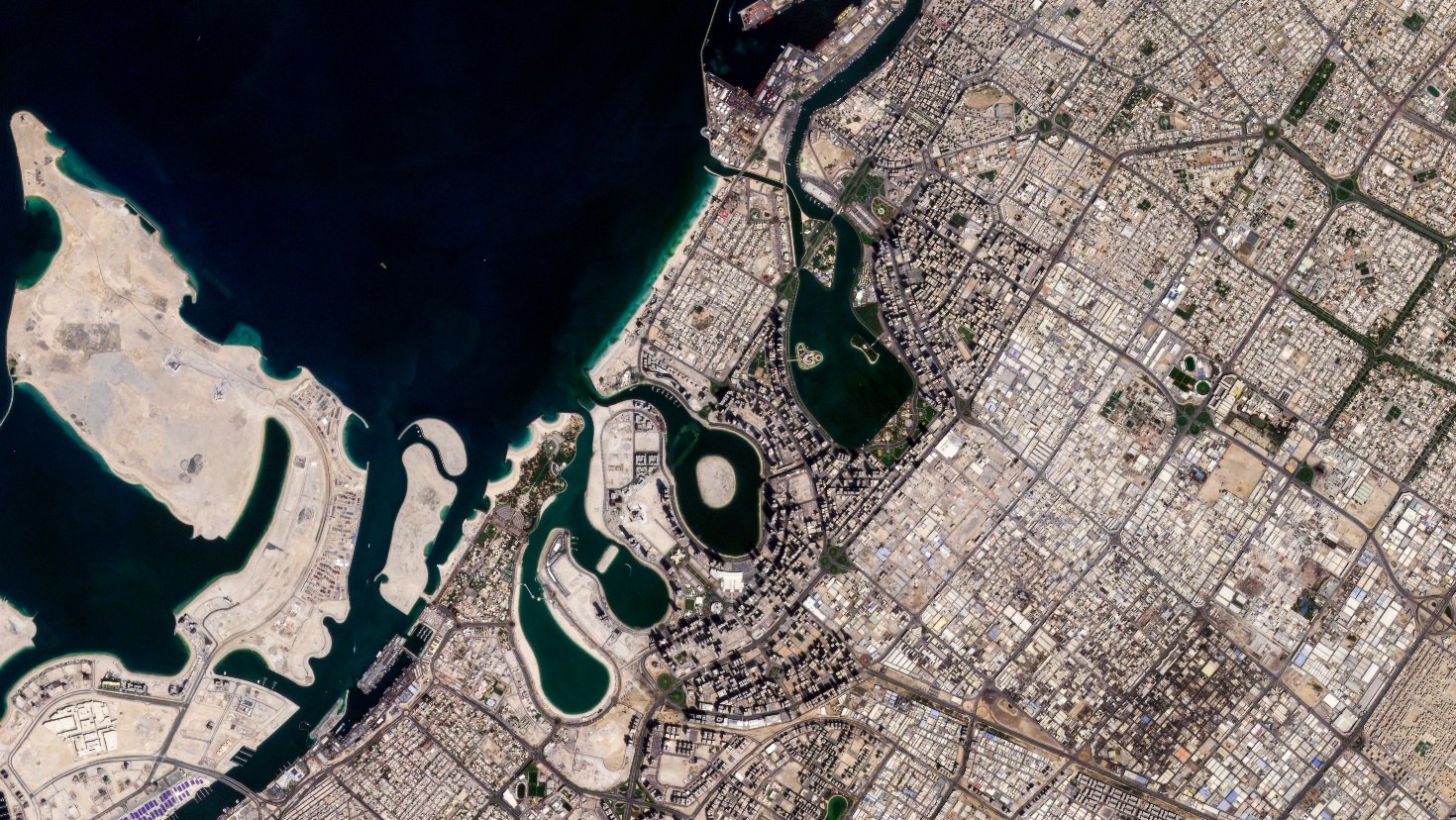
Figure 6 — Dubai, United Arab Emirates, before the strike: the urban fabric along the lagoon appears intact. Source: Planet Labs PBC.
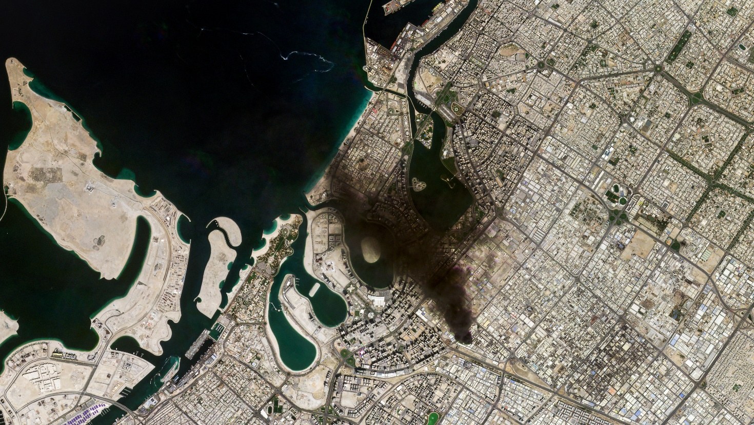
Figure 7 — Same sector after an Iranian retaliatory missile strike: a large plume of black smoke spreading over the urban area is visible. Source: Planet Labs PBC.
This is where the parallel with Ukraine becomes inevitable. In that case too, many observers initially underestimated the systemic weight of the conflict. Only after observing the effects on energy prices, on supply chains, on European security did it become clear that it was not a peripheral war.
Iran occupies an even more delicate position: it sits at the crossroads of Central Asia, the Middle East, and global maritime corridors. It borders Iraq and Afghanistan, faces the Persian Gulf and the Gulf of Oman, and is a few hundred kilometers from the world’s main energy hubs. The maps of the strikes show that the conflict runs precisely through these nodes.
Another fact deserves attention: the density of events in the initial 48 hours of 2026 is significantly higher than in the June 2025 phase. Not just more sites hit, but greater territorial dispersion. In terms of conflict analysis, this points to a political threshold that has been crossed. Accepting to strike deep into a territory spanning more than 1.6 million square kilometers implicitly redefines the perimeter of risk.
The direct or indirect involvement of US bases in the Gulf adds a further layer of complexity. Saudi Arabia, the Emirates, Qatar are not mere geographic bystanders: they are part of the regional security infrastructure. Their exposure increases the probability of a regionalization of the conflict, even without a formal declaration of a wider war.
What scenarios are emerging?
The first is a full regional escalation, with the activation of non-state actors in Lebanon, Syria, Yemen. The second is an intermittent war, characterized by cycles of attack and reprisal against strategic infrastructure. The third is a negotiated freeze that re-establishes a form of mutual deterrence.
In all three cases, however, one conclusion appears hard to avoid: Iran is not a periphery. The strike maps show a country that, when it enters direct war, alters the balance of an entire energy and military region. The data on the geographic distribution of the strikes, on territorial depth, and on proximity to strategic corridors indicate that we are facing a structural transformation, not a contingent episode.
The maps do not just show where the bombs fall. They show where the center of gravity of the international system is shifting.
And today that center of gravity, whether we like it or not, runs through Iran and the Gulf.