The European satellite that sees when others go dark
How Bellingcat's tool for documenting conflict damage in Iran works — and why it matters — built on Sentinel-1, Copernicus' public radar
by Piero Boccardo
On 7 April 2026, the investigative journalism organisation Bellingcat released an updated version of the Iran Conflict Damage Proxy Map — a public tool that, drawing on data from the European Sentinel-1 satellite, flags areas of Iran and the Persian Gulf where the ground surface has changed in a statistically anomalous way since hostilities began. The map, available online and freely accessible, updates once or twice a week, in step with the satellite’s passes.
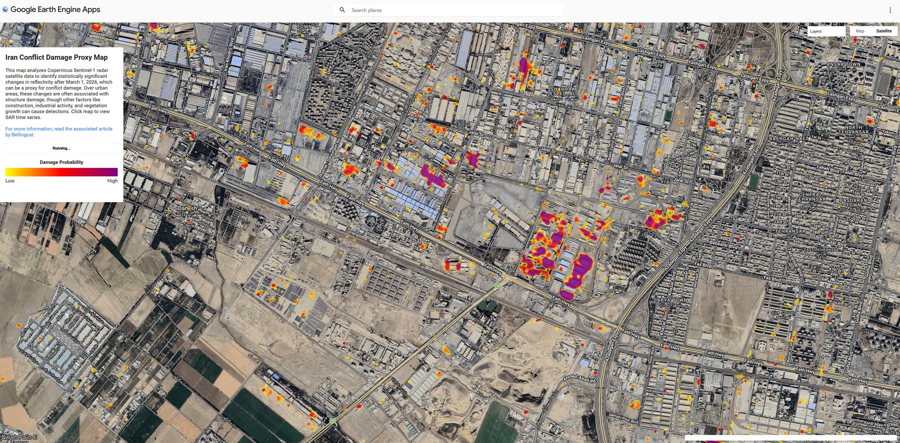
Screenshot from Bellingcat’s Iran Conflict Damage Proxy Map over an area west of Tehran, around the Fath Highway axis (Tehransar and Shahrak Esteqlal districts). Coloured pixels indicate areas where the Sentinel-1 radar signal has changed in a statistically anomalous way relative to the period before 1 March 2026: yellow corresponds to the lowest damage probabilities, violet to the highest. — Bellingcat / Ollie Ballinger — Sentinel-1 © Copernicus / ESA
The tool was built to answer a concrete problem. For several weeks, at the request of the US government, the main commercial operators of high-resolution optical satellites have suspended or restricted the distribution of recent imagery over Iran. A significant share of the photographs that appear in newspapers when reporting on military sites, airports, government buildings struck by attacks comes from these private operators: Maxar, Planet, Airbus. When they choose — or are compelled — not to publish, the flow of information to journalists, researchers and humanitarian organisations narrows.
Bellingcat therefore built a tool that does not depend on optical imagery and instead draws on a different class of satellites: Synthetic Aperture Radars, known by the acronym SAR. SAR satellites emit microwave pulses toward the Earth and measure the echo that returns. They operate at night, because they are independent of sunlight, and they see through clouds and rain because microwaves are not blocked by the atmosphere. Crucially, the Sentinel-1 programme is part of Copernicus, the European Union’s and the European Space Agency’s public Earth-observation infrastructure: the data are free, open, and their distribution cannot be suspended at the request of any single government.
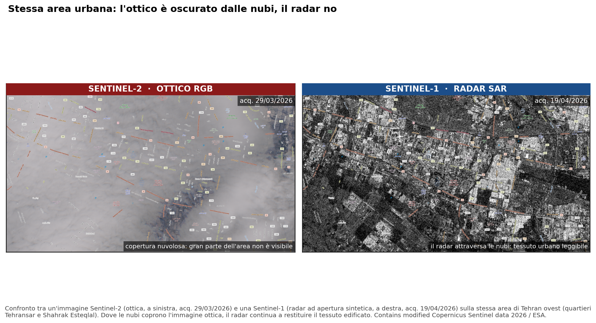
Comparison between a high-resolution optical image (left) and a Sentinel-1 SAR image (right) over the same site in Iran. The radar operates independently of cloud cover and time of day — decisive characteristics when commercial optical operators restrict distribution. — Sentinel-1 © Copernicus / ESA
The method Bellingcat’s map uses to identify “suspect” areas is called the Pixel-Wise T-Test, developed by geographer Ollie Ballinger. The principle is straightforward. For each pixel of the study area, a year’s worth of radar observations prior to the start of the conflict is collected. From these, a “normal” baseline is calculated — the expected mean and variability of the radar signal at that point. Then, each time a new Sentinel-1 image arrives, the current pixel value is compared to the historical record. If the new value falls outside the range that 99 per cent of observations would occupy under ordinary conditions, the pixel is flagged. This does not prove that damage has occurred, but it indicates that something has happened there that falls outside the norm: a collapsed building, a destroyed road, an emergency construction site, a fire. The journalist’s or researcher’s task is to take that flag and verify it.
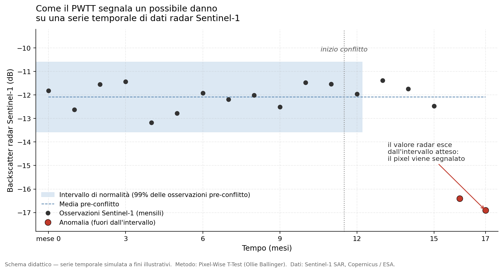
Diagram of the Pixel-Wise T-Test method applied to Sentinel-1 imagery. For each pixel, a reference distribution is built on an annual basis; each new acquisition is then statistically compared against this baseline. — Elaboration: Ollie Ballinger / Bellingcat
Bellingcat has tested the accuracy of the approach on a large sample: over two million buildings mapped by the United Nations Office for the Coordination of Humanitarian Affairs (OCHA) across around thirty cities in Gaza, Ukraine, Sudan, Syria and Iraq. In contexts with heavy cloud cover, without useful night-time windows, or where private operators had not found it commercially viable to cover an area, the public radar continued producing data. This is the case in Sudan, for example, where the civil war of recent years has been poorly covered by commercial imagery because there was no market for it, and where Sentinel-1 has become one of the primary reference tools for those trying to reconstruct the conflict’s impact.
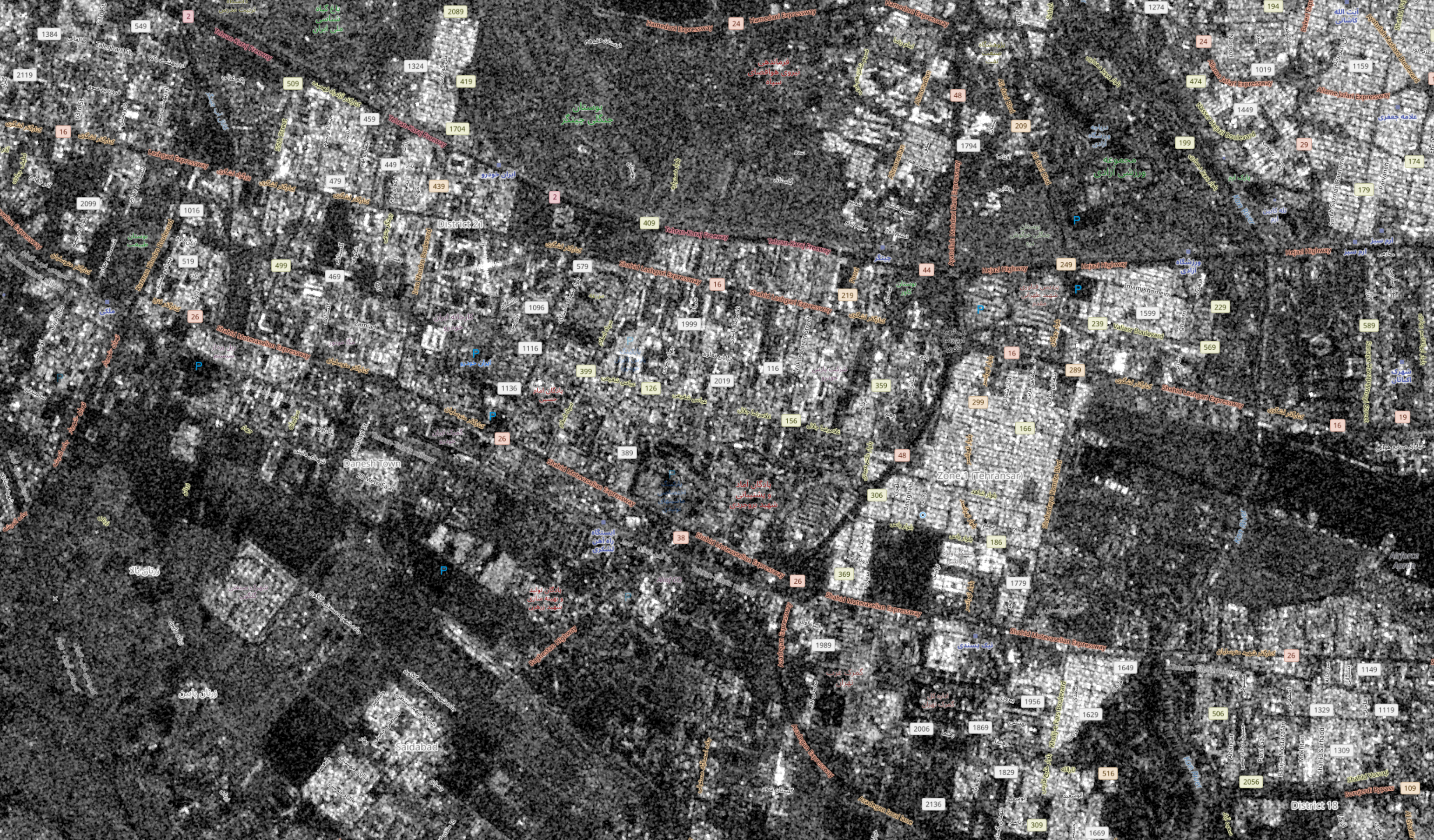
Sentinel-1 image under clear-sky conditions: the quality of the radar signal does not vary with changing atmospheric conditions, unlike optical sensors. — Sentinel-1 © Copernicus / ESA
The difference with commercial optical satellites is not only technical: it is also political. Maxar and Planet operate under licences issued by the US government; their terms of use include the possibility — known as shutter control — for the US administration to request distribution restrictions when national security concerns arise. Copernicus was conceived in the opposite direction: the Sentinels are missions of the European Space Agency, funded with EU public money, and the principle of open data is written into European regulations. There is no political switch with which any single government can turn them off.
This architecture is not perfect. Sentinel-1 has a resolution of approximately twenty metres, useful for identifying changed areas but not for recognising individual details, and revisit times of several days rather than a few hours. But it is precisely in the combination of open data, continuity of service, and the possibility for anyone to build tools like Bellingcat’s on top of it, that the value of the infrastructure is defined.
The moral, in the end, goes beyond Iran or the Gulf. It concerns the fact that the ability to observe a conflict from above, and to document it independently, is not a natural function of satellites: it is a choice. It depends on who owns them, who pays for them, under what conditions of use their output is regulated. Having at least one public, European, un-switchable-off infrastructure means having an accountability tool that stays on even when someone would like to dim the lights. And this is one of the reasons — perhaps underappreciated — why Copernicus is one of the highest-impact civilian scientific programmes the European Union has built in the last twenty years.