Antelope Reef: from coral reef to artificial island in under a year
Two high-resolution SkySat images, from August 2025 and June 2026, show the transformation of a Paracel Islands atoll into new Chinese infrastructure
by Piero Boccardo
The starting point
“The Growing Archipelago” (“L’arcipelago che cresce”), published on Linkiesta, described how China has for years been turning reefs and shoals in the South China Sea into permanent outposts: dredging the lagoon floor, filling it with sand, consolidating a usable surface, then building civilian and military structures. All of this happens on features China claims under the so-called “nine-dash line,” a territorial claim the Permanent Court of Arbitration in The Hague ruled had no legal basis in 2016, but which Beijing continues to treat as valid. That transformation remains visible almost only through commercial satellites (Planet, Maxar, BlackSky), since Copernicus, Europe’s public satellite programme, does not systematically cover this part of the world.
This piece returns to the same subject with a single case, followed through a pair of images that are rarely available side by side: the same atoll, the same framing, ten months apart. Antelope Reef (Lingyang Jiao, 羚羊礁 in Chinese) is a small atoll in the Crescent Group of the Paracel Islands, administered by China since 1974 and also claimed by Vietnam and Taiwan. The two images below were acquired by Planet Labs PBC’s SkySat satellites at roughly half a metre resolution: the first on 10 August 2025, the second on 18 June 2026. Both were cropped to the exact same geographic footprint, pixel for pixel, based on the GeoTIFF georeferencing tags of the original files (ModelPixelScale and ModelTiepoint): sliding between them shows precisely the same patch of sea, and zooming in keeps that alignment intact.
One atoll, two seasons
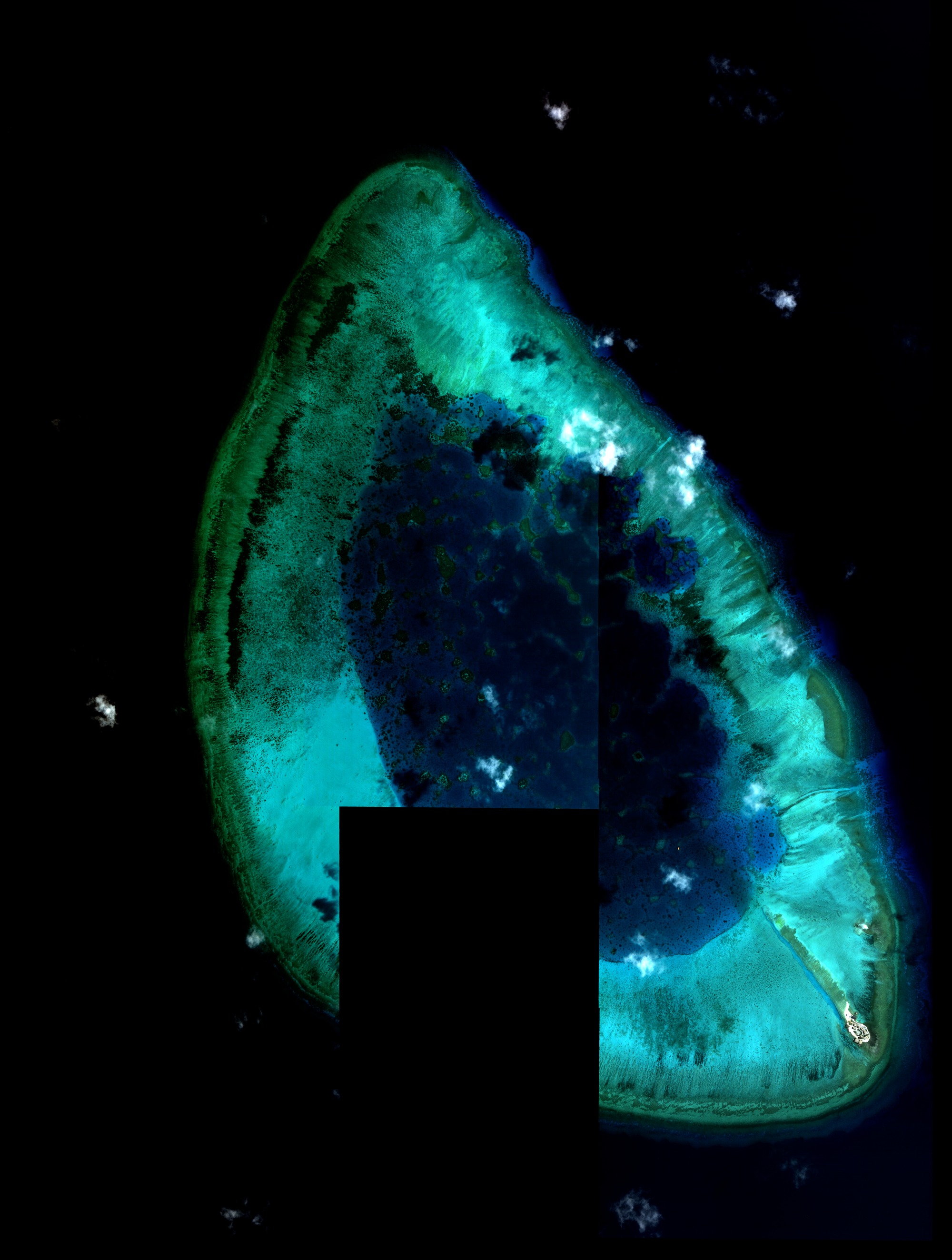
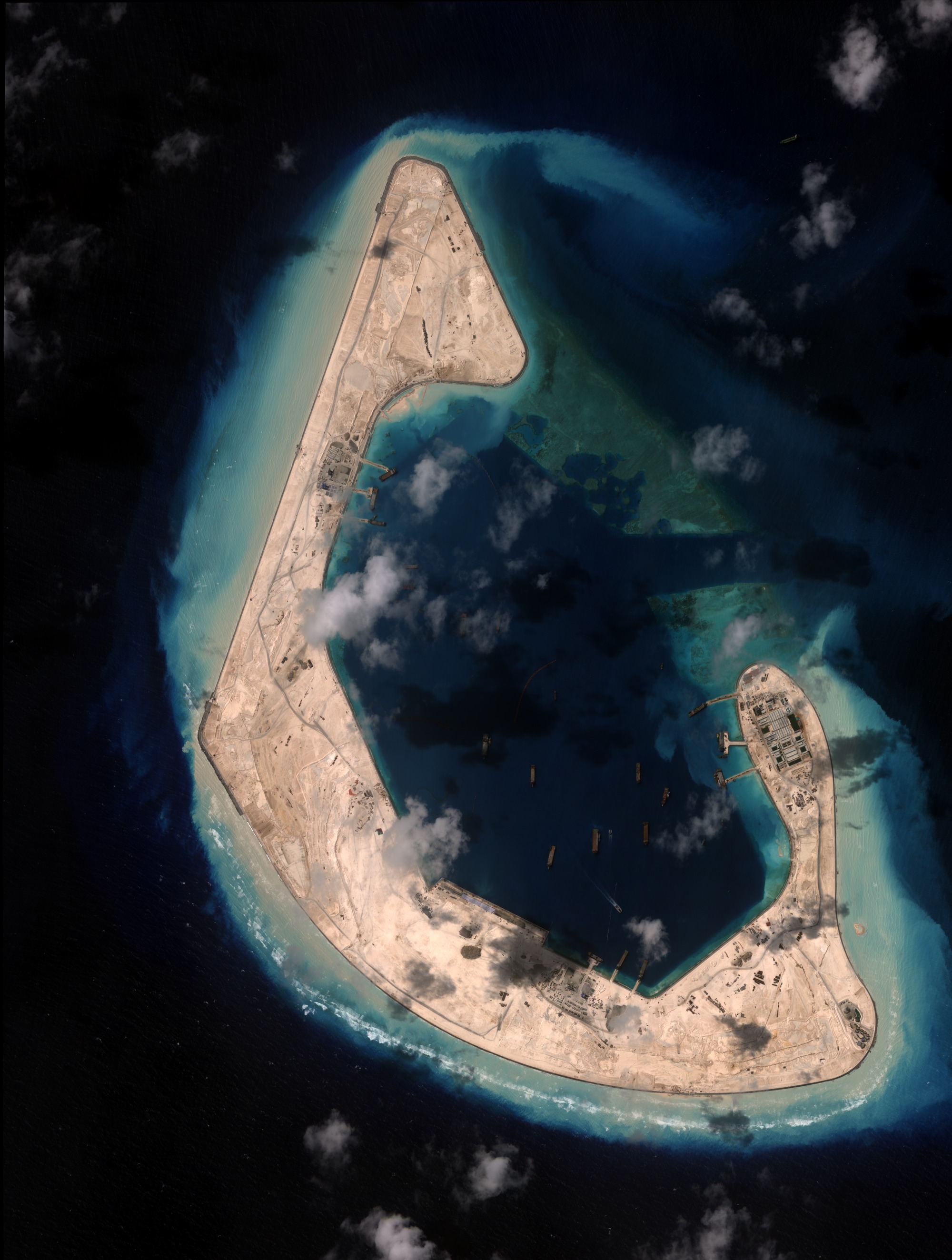
Figure 1. Antelope Reef, 10 August 2025 / 18 June 2026, at full resolution: drag the bar to compare, use the scroll wheel or the buttons to zoom in, and drag to pan once zoomed in. Source: Planet Labs PBC (SkySat).
In the first image the atoll is still in its natural form: a horseshoe-shaped reef rim, only a few dozen metres wide, enclosing a shallow lagoon. Ten months later that same rim has become a continuous strip of land hundreds of metres wide, crossed by tracks and roads, with several clusters of buildings, an internal harbour area, and a second artificial islet where in 2025 there was only a sand mound. The sections below read the 2026 image point by point, with a close-up detail for each area, comparing it against the same area in 2025.
What the 2026 image shows, element by element
The northern spit. The sharpest point at the north end of the atoll did not exist in 2025: it was submerged reef flat, visible only as a thin green-turquoise crescent under a few centimetres of water, with no dry land at all. In the 2026 image it is a completed reclamation promontory, bordered by a dark, regular edge that is almost certainly an artificial rock-armour breakwater built to stabilise the perimeter against wave action. Its surface shows a network of unpaved tracks converging toward the tip, some lighter, levelled patches, likely material stockpile yards or graded pads awaiting construction, and small dark shapes lined up along the eastern edge, consistent with containers or lightweight site structures. No permanent buildings are yet visible on this stretch: it is the “youngest” part of the island, still being consolidated.
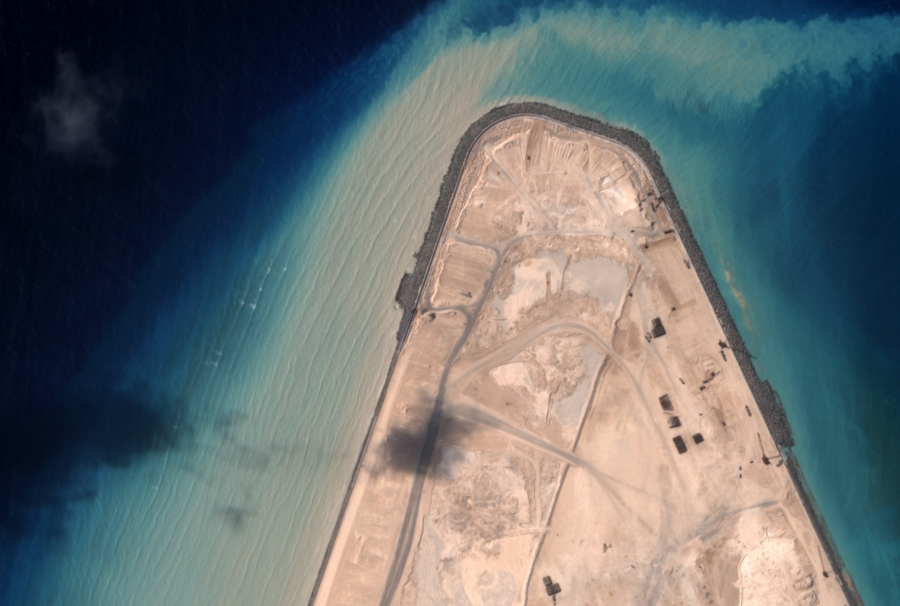
Detail of the northern spit, 18 June 2026: the artificial rock-armour breakwater, the network of tracks, and the levelled yards, with no permanent buildings yet. Source: Planet Labs PBC (SkySat).
The western arm and the harbour area. Moving down the western arm, a well-graded service road runs the length of the crest. About a third of the way from the northern tip sits the island’s most developed cluster: a group of light-roofed buildings arranged in regular rows, flanked by several dark circular shapes whose size and placement are consistent with storage tanks (fuel or water), and a bluish rectangular block that has the look of a small solar-panel array. A short distance away, an area divided into regular, purplish-toned cells is also visible, which could correspond to water-treatment basins or a small service pond. Three jetties extend from this cluster into the lagoon, all with service vessels moored alongside; the elongated shape and oxidised colour are typical of work barges or pontoons rather than pleasure craft. In 2025 this entire stretch was still submerged reef, exposed only at low tide, with no structures whatsoever.
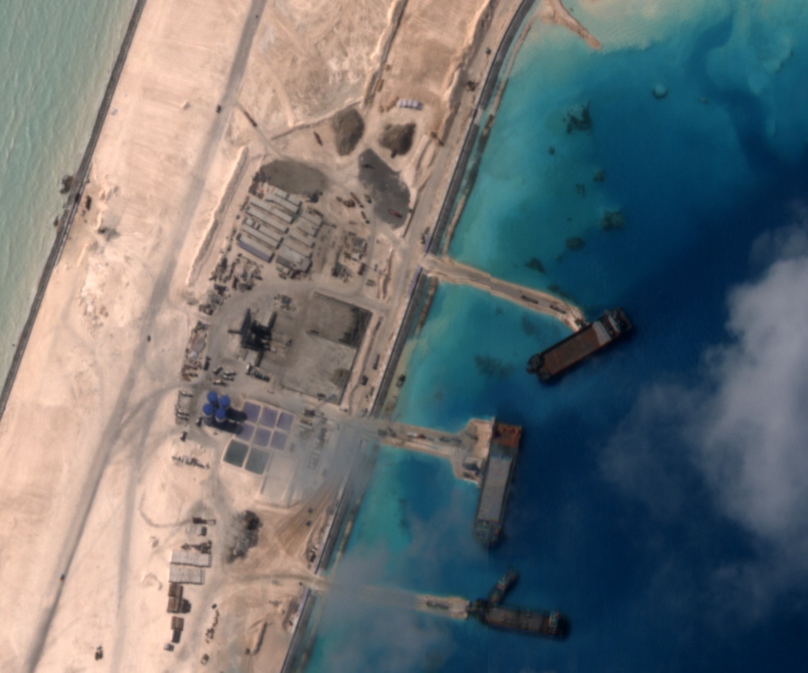
Detail of the harbour area on the western arm, 18 June 2026: buildings, storage tanks, a solar-panel array, and three jetties with service vessels moored alongside. Source: Planet Labs PBC (SkySat).
The southern arc and the dredging fleet. The broader southern curve hosts the island’s largest complex in 2026: further building clusters, construction yards, a network of intersecting roads, and an area facing the inner lagoon where numerous vessels are moored. Counting the shapes visible in the inner lagoon alone yields around fifteen, scattered with no particular order: almost certainly barges, pontoons, and dredging equipment. One detail stands out: a thin, curved, reddish line floating on the water’s surface for hundreds of metres, connecting a point in the lagoon to a dredger, almost certainly a floating pipeline used to pump the sand-and-water slurry from the dredging point to the area being filled. Its presence indicates that on 18 June 2026, the date of the image, lagoon-filling operations were still under way: the atoll’s transformation, in other words, was not yet complete.
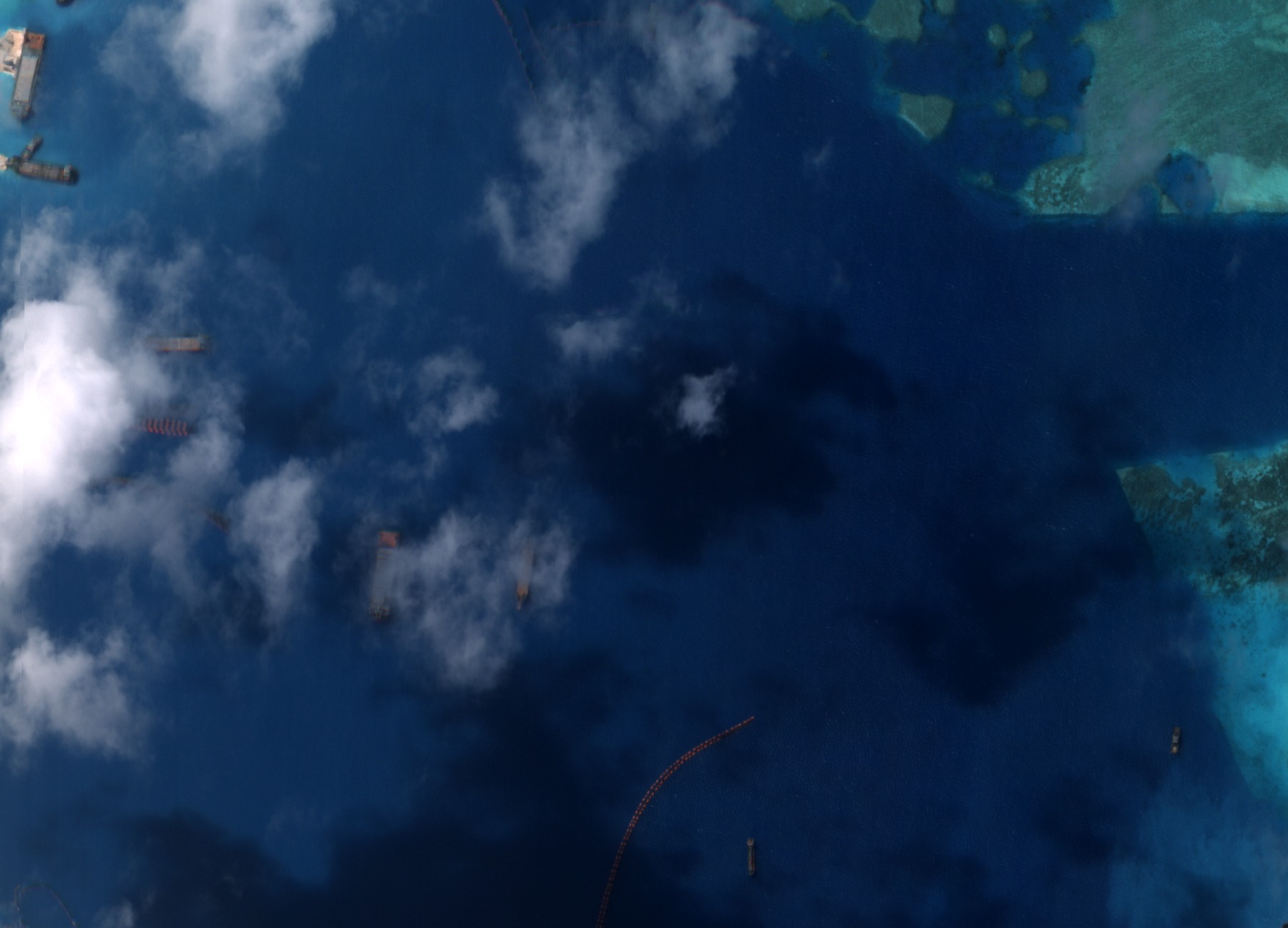
Detail of the inner lagoon, 18 June 2026: barges and dredging equipment moored, and the reddish line of a floating pipeline still in operation. Source: Planet Labs PBC (SkySat).
The new southeastern islet. In the 2025 image, at the southern tip of the reef, only a small elongated sand mound is visible, little more than a bar exposed at low tide, separate from the rest of the atoll. In 2026 the same spot hosts a freestanding, oval-shaped artificial islet, connected to the rest of the structure by a causeway-pier crossing the lagoon. A small, compact settlement is visible on the islet: rows of light-roofed buildings arranged in an orderly pattern, an area marked with a white circle and the letter “H”, standard helipad markings, and a few green rectangles inside the compound’s perimeter, which could be courtyards, green areas, or covering material. Besides the main causeway-pier connecting the islet to the rest of the structure, a second, smaller pier faces the opposite side, with another service vessel moored alongside. The modest size and the presence of a dedicated helipad suggest a small support outpost, distinct and separate from the main construction site on the larger strip of land.
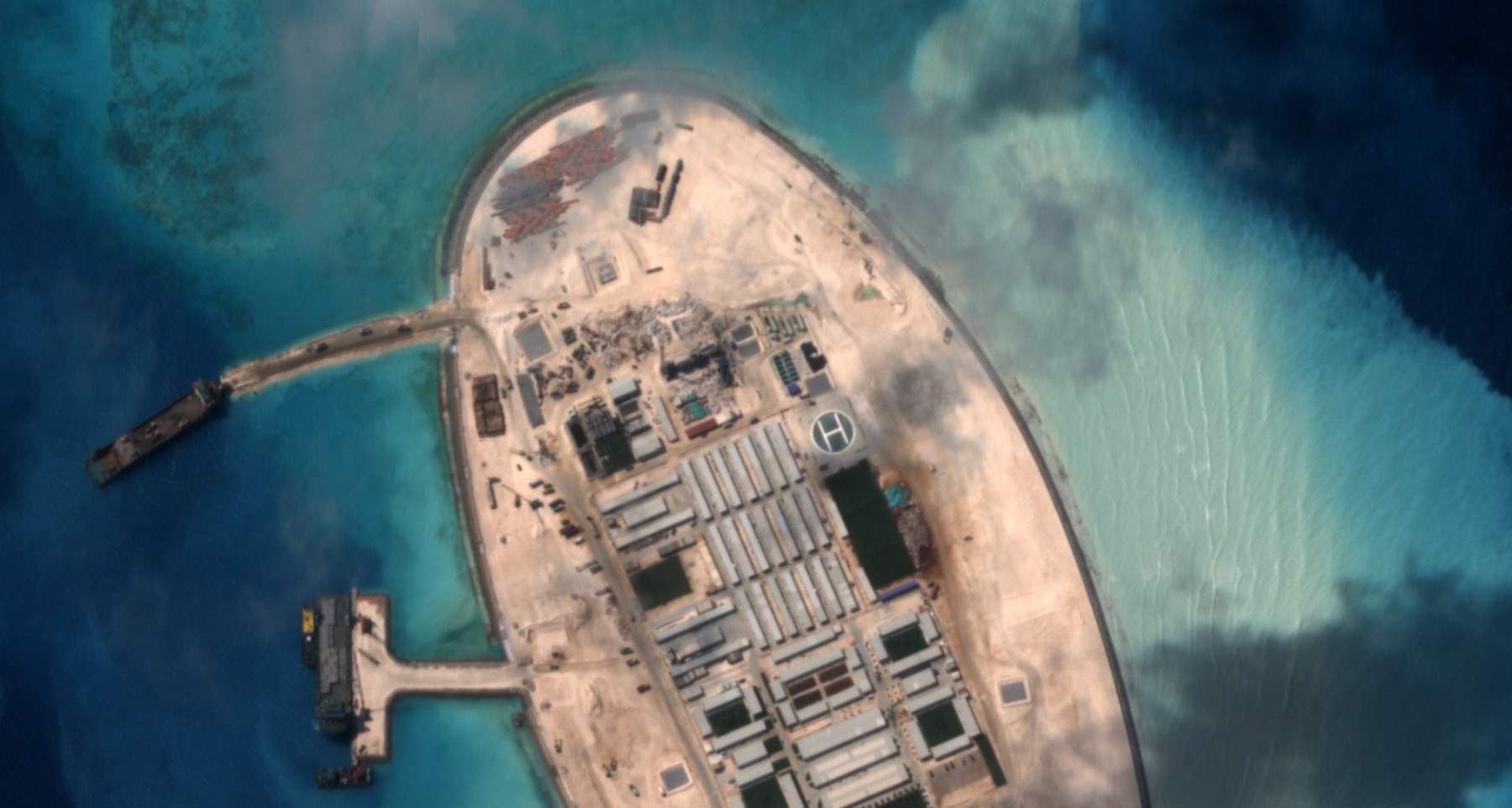
Detail of the southeastern islet, 18 June 2026: the connecting causeway-pier, the rows of buildings, and the helipad marked with the letter “H”. Source: Planet Labs PBC (SkySat).
The black rectangle in the lagoon. A small black rectangle in the middle of the lagoon, present only in the 2025 image, corresponds to an area not covered by that date’s satellite acquisition rather than a processing flaw: it has been left visible for transparency instead of being hidden or artificially filled in.
One case, a broader pattern
Antelope Reef is not an isolated case. It follows the same pattern described in “The Growing Archipelago” for the Spratly Islands further south: dredging the seabed, filling it with sand, consolidating a usable surface, then building permanent structures. Here, however, the process can be observed on a much shorter timescale (ten months) and with a pair of images that match point for point, which makes the transformation unusually legible even to a non-specialist audience. The dredging pipeline still active in the June 2026 image is a reminder that this is an ongoing process, not a finished fact: future acquisitions could show further expansion of the built-up area, particularly on the northern spit, the only stretch of the atoll where consolidation still appears to be at an early stage.
External confirmation and reactions
In the days following the completion of construction, the Antelope Reef case was picked up by several international outlets on the basis of fresh satellite imagery analysis. AMTI (the Asia Maritime Transparency Initiative at CSIS) places the feature at 16°27’45”N, 111°35’20”E and estimates the total reclaimed area at about 1,490 acres, a little over 600 hectares.
According to satellite imagery analysis carried out by Reuters, the island now measures almost six kilometres in length, with a rectilinear coastline of more than three kilometres whose shape is compatible with a future runway of about three thousand metres, a length comparable to those already built on Woody Island, Fiery Cross Reef, Subi Reef and Mischief Reef. A pier roughly 680 metres long now reaches into deep water, offering port access suitable for larger vessels.
The same sources place the start of construction around December 2025 (an initial identification by analyst Damien Symon) and the departure of construction equipment by 19 July 2026, for an overall building period of about six months. This timeline matches what our own 18 June 2026 image shows, captured roughly a month before the completion reported by Reuters: the still active dredging pipeline described above confirms that, at that date, the site was indeed in its final phase but not yet finished.
Vietnam, which has never recognised China’s 1974 seizure of the Paracels, filed a formal diplomatic protest reasserting its claim over the whole archipelago. Some analysts quoted by Reuters, including Ben Lewis, describe Antelope Reef’s position as particularly valuable in a Taiwan conflict scenario, and suggest the island could eventually outrank nearby Woody Island, seat of China’s Southern Theater Command and already home to fighter aircraft and surface to air missile systems. Beijing presents the project as civilian in purpose, oriented toward scientific research and meteorology, while security analysts read it as part of a broader military consolidation of the northern South China Sea.
Methodological note
The two images derive from Planet SkySat “Surface Reflectance” products (4 bands, 16 bits per channel), processed as a true-colour composite (red, green, blue bands) with independent normalisation for each date. The geographic crop was aligned pixel for pixel using the original GeoTIFF georeferencing tags (ModelPixelScale and ModelTiepoint), not a simple visual match of the two frames. The compare tool above uses the same image pair as the static figures, at the highest resolution currently available for online publication. The four close-up details come from the same 18 June 2026 SkySat image, cropped and resampled with no further colour processing.
Sources
SkySat imagery analysis, Planet Labs PBC, by Piero Boccardo, Politecnico di Torino. For general context on artificial islands in the South China Sea, see also “L’arcipelago che cresce” (“The Growing Archipelago”) on Vista dall’alto and on Linkiesta.
For the most recent developments and international reactions, see Reuters (19 August 2026), BBC News (20 August 2026), Analisi Difesa and La Discussione (in Italian), as well as the “Antelope Reef” feature page from AMTI (the Asia Maritime Transparency Initiative, CSIS).